An official website of the United States government
Here’s how you know
Official websites use .gov
A .gov website belongs to an official government organization in the United States.
Secure .gov websites use HTTPS
A lock (
) or https:// means you’ve safely connected to the .gov website. Share sensitive information only on official, secure websites.
-
//
- Census.gov /
- Our Surveys & Programs /
- Statistics in Schools /
- Resources /
- Maps /
- Territorial Acquisitions Map
Territorial Acquisitions Map
Share

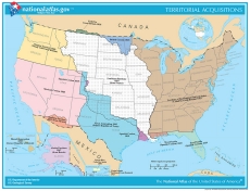
The 1997-2014 Edition of the National Atlas has prepared a Territorial Acquisitions map of the United States that you can print. This map portrays the major acquisitions of territory by the United States from 1783 to the present. Areas in North America, the Caribbean, and Hawaii are included. The map is in color, but will also print or copy well in black and white.
These map pages are in a standard 8.5- by 11-inch landscape format.
Map courtesy of U.S. Department of the Interior, U.S. Geological Survey.
Download the Map
The content on this page includes a link to a non-government website. Our linking to these sites does not constitute an endorsement of any products, services or the information found on them. Once you link to another site you are subject to the policies of the new site.
 Yes
Yes
 No
NoComments or suggestions?


Top


