Decoding State-County Census Tracts versus Tribal Census Tracts
Decoding State-County Census Tracts versus Tribal Census Tracts
The U.S. Census Bureau offers thousands of statistics at hundreds of geographic levels. Census Bureau geographies help us organize all of this information. One of the most popular levels of geography used in statistical analysis is the census tract, which is used in community planning, grant writing, real estate, research and much more.
Census tracts are subdivisions of counties, with approximately 4,000 people per tract. They are relatively stable over time, allowing for comparisons of data over time. The Census Bureau offers two types of census tracts: the standard state-county census tracts and tribal census tracts. You may even live in an area covered by both types of census tracts if you live on a federally-recognized American Indian reservation or off-reservation trust land.
State-county census tracts are small statistical subdivisions of a county or county equivalent. They cover the entire U.S. and provide a stable set of geographic units for presenting statistical data. Because they are defined by population—ideally about 4,000 people—they can vary greatly in land area. A standard census tract must be entirely within one county and cannot cross into another county. Census tracts do not have to follow other boundaries, such as places or county subdivisions.
Tribal census tracts are small statistical subdivisions of a reservation and off-reservation trust land. Their primary purpose is the same as census tracts: the presentation of statistical data. However, rather than nesting within a county, tribal census tracts nest within a single federally recognized American Indian area, providing coverage across all federally recognized American Indian reservations and off-reservation trust lands. Tribal census tracts have population criteria identical to county-based census tracts.
The Census Bureau first introduced tribal tracts for Census 2000. Working with local government officials and tribal officials, we took existing state-county census tracts and reshaped them to fit reservation and off-reservation trust land boundaries. We then gave them each an ID ranging from 9400-9499. This did not always meet the needs of the population within the federally-recognized American Indian reservations and off-reservation trust lands, nor did it always meet the needs of population within the counties.
For the 2010 tribal tracts, we worked with tribal officials to draw more meaningful boundaries independent of the standard county-based census tracts. They have a six-digit ID (4 characters and a two-character suffix that may not be displayed if the suffix is “00”) that begins with a T.
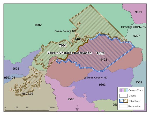
Here is a map showing both 2010 census tracts and 2010 tribal tracts:
Standard county-based census tracts often cannot be fully utilized by those living on American Indian reservations because these tracts often do not conform to their reservation boundary. Let’s say you are a tribal member interested in studying the number of children under the age of 5 who live in the southeastern part of your reservation. You could obtain data for state-county census tract 9402 but would not know how many children actually live within the reservation boundary since 9402 covers territory both in and out of the Eastern Cherokee Reservation. However, if you obtain data for tribal tract T002, you would ensure the data represents the population you would like to research.
There are many similarities between standard census tracts and tribal tracts. They both use the same population criteria, with a minimum population of 1,200, a maximum population of 8,000, and an optimum population of 4,000. For both types of tracts, we try to use visible features as boundaries, such as roads and rivers and try to maintain stable boundaries so you can compare data over time. In addition, both sets of boundaries are mostly defined by local governments. County-based census tracts are defined through the Participant Statistical Areas Program (PSAP) and tribal census tracts are defined through the Tribal Statistical Areas Program (TSAP).
The following table lists differences between census tracts and tribal tracts:
| State-County Census Tracts | Tribal Census Tracts |
|---|---|
| Unique to and nested within the county | Unique to and nested within the Reservation |
| Can cross state and county lines | |
| Can be discontinuous | |
| Numeric 6 digit name (e.g. 3042, 1801.02) | Name starts with a ‘T’ (e.g. T001, T002) |
| Cover the entire U.S. | Cover only Federally-recognized American Indian Areas with land |
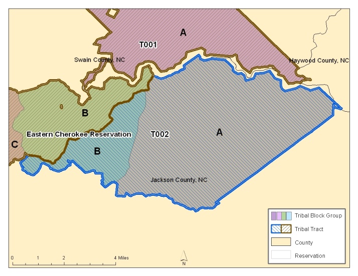
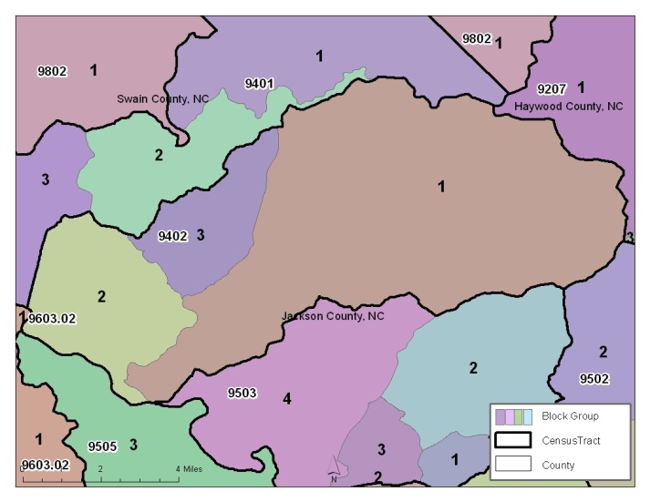
Just like there are two types of census tracts, there are also two types of block groups: state-county-tract block groups, which nest within census tracts, and tribal block groups, which nest within tribal tracts. Both types of block groups are shown below:
Both types of block groups are similar in the same way the two types of census tracts are. The following table lists their differences:
| State-County-Tract Block Groups | Tribal Block Groups |
|---|---|
| Unique to and nested within the census tract | Unique to and nested within the tribal tract |
| Can cross state and county lines | |
| Can be discontinuous | |
| Numeric single digit name (e.g. 1,2,3) | Alpha character name (e.g. A,B,C) |
| Cover the entire U.S. | Cover only Federally-recognized American Indian Areas with land |
For more information about census tracts and block groups, please visit the Census Geographic Terms and Concepts. If you would like to view the 2010 census tracts, block groups, tribal tracts, and tribal block groups, you can do so on TIGERweb. Finally, you can access demographic data for these boundaries using American FactFinder.
For an overview of the importance of Census Bureau geographies, see the previous blog post, Why is Geography Important to the Census Bureau?


