
end of header
History
You are here: Census.gov › History › Home Page Archive › 2023 › April 2023
2022
April 2023
Visit https://www.census.gov/history every month for the latest Census History Home Page!
U.S. Census Bureau History: The 1803 Louisiana Purchase
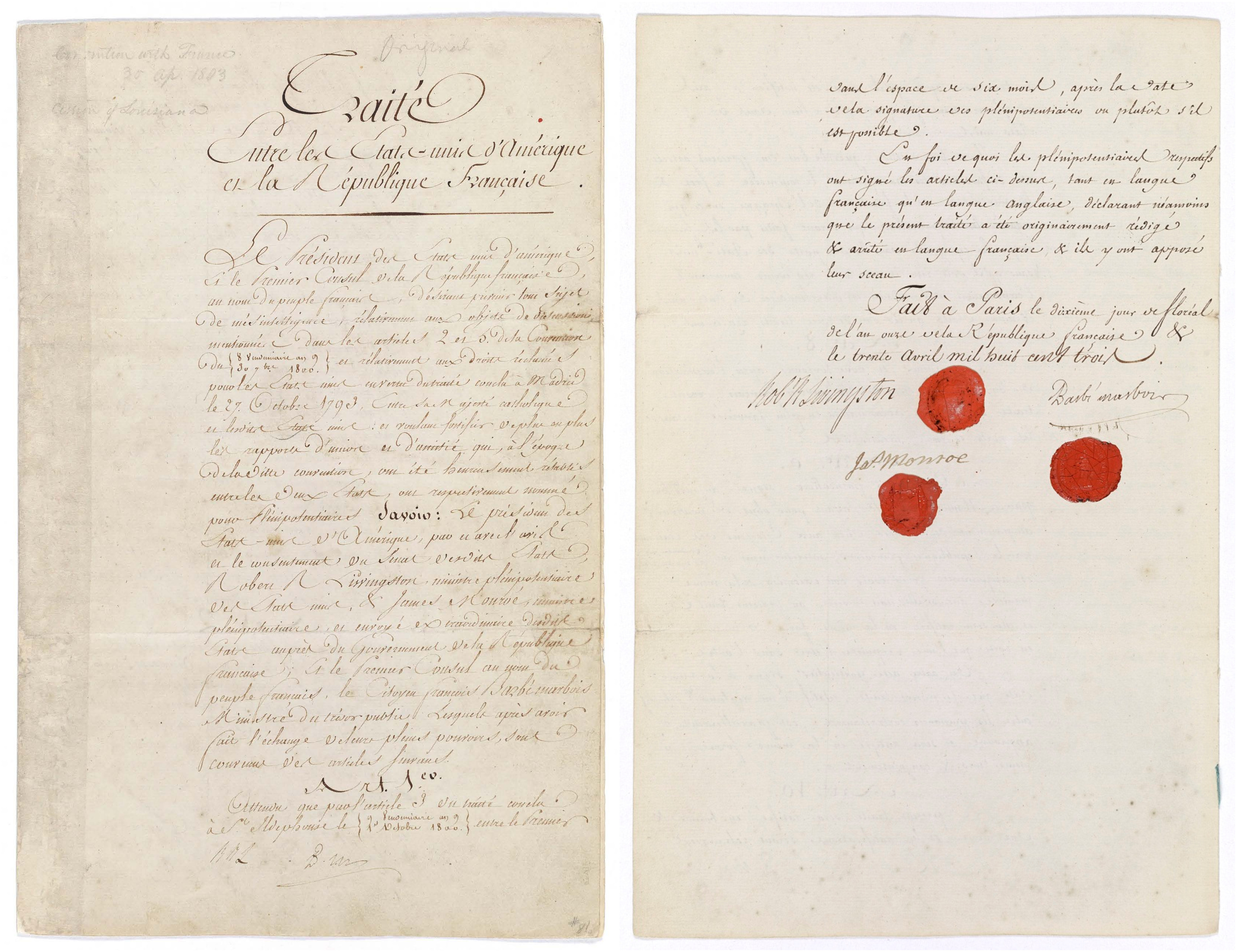
The Louisiana Purchase Treaty signed by American diplomats Robert Livingston and James Monroe and French
representative Francois Barbe-Marbois on April 30, 1803.
The treaty nearly doubled the size of the United States for the "bargain" price of just $15 million!
Photo courtesy of the National Archives and Records Administration.
On April 30, 1803, representatives of the United States and France signed the Louisiana Purchase Treaty. Authorized by President Thomas Jefferson to purchase the vital Mississippi River city of New Orleans, LA, for no more than $10 million, the American delegates Robert Livingston and James Monroe were stunned by a French offer to sell more than 828,000 square miles of land bordered by Canada in the north and the Rocky Mountains in the west for $15 million dollars—just 3 cents per acre! Certain of Jefferson approval, Livingston and Monroe quickly signed the agreement before the French could withdraw the offer.
In 1803, the western boundary of the United States—including the newly admitted 17th state of Ohio (March 1, 1803)—was the Mississippi River. The nation was bordered by British Canada to the north, Spanish Florida to the south, and a vast expanse of French territory west of the Mississippi. France claimed the territory in 1682 and named the region "La Louisiane" in honor of King Louis XIV. Initially, limited financial resources prevented widespread French settlement of the territory. American Indians far outnumbered French settlers, trappers, traders, and soldiers, the latter of which often numbered just a few hundred assigned to protect the entire territory. By the mid-1700s, Canadian French and American Indian settlements dotted the northern territory, like Kaskaskia, IL, and Ste. Genevieve, MO— while in the south Mobile, AL, Biloxi, MS, and New Orleans, LA, were rapidly growing centers for French colonial government and important transportation hubs with access to the water and land trade routes. Although Spain gained control of much of France's North American territory following the French 1763 defeat in the Seven Years' War, France regained control of the territory in 1800. At that time, access to the Mississippi River and trade routes was of particular interest to the United States. With the arrival of French troops in New Orleans in 1801, Americans grew concerned that tensions between the United States and France could disrupt their trade along the Mississippi River.
Hoping to avoid hostilities along the Mississippi River and safeguard American trade along the Mississippi River to the Gulf of Mexico, President Thomas Jefferson authorized diplomat Robert R. Livingston to begin negotiating for the purchase of New Orleans from France in 1801. Little progress was made over the next year as France was preoccupied with its Caribbean colonies, including a slave rebellion on Saint-Dominique (present-day Haiti). In early 1803, Pierre Samuel du Pont de Nemours—a mutual friend of both President Thomas Jefferson and French leader Napoleon Bonaparte—began secret negotiations for an American purchase of all of French Louisiana. In need of funds for an anticipated war with Great Britain, unable to protect Louisiana from potential British invasion, and facing resistance, disease, and declining sugar profits in the Caribbean, Napoleon agreed to abandon North America.
Following Napoleon's instructions, Treasury Minister Fracois Barbe-Marbois offered all of French Louisiana to Livingston for the "bargain price" of just $15 million. Livingston was dumbfounded. Authorized to spend no more than $10 million to purchase the city of New Orleans, he now had the opportunity to nearly double the size of the United States for less than 3 cents per acre! Fearing Napoleon would withdraw the ridiculously low offer, Livingston and fellow diplomat (and future president of the United States) James Monroe did not wait for President Jefferson's approval. They signed the Louisiana Purchase Treaty on April 30, 1803.
Livingston and Monroe returned to Washington, DC, where an official announcement of the Louisiana Purchase Treaty was made on July 4, 1803  . Despite questions about its constitutionality, concerns about expanding slavery, potential shifts in political power, and questions about granting citizenship to the region's inhabitants, the Senate ratified the Louisiana Purchase Treaty on October 20, 1803, and the House of Representatives approved funding the purchase. The next day, the Senate authorized Jefferson to establish a temporary military government in the Louisiana Territory. By the end of October, legislation had been enacted to establish local government, send military units to the region, and make plans to explore and map the territory—including Lewis and Clark's 1803–1806 Corps of Discovery Expedition. In 1804, the territory was divided into the Territory of Orleans administered from New Orleans and the northern Louisiana Territory with its capital at St. Louis, MO.
Less than a decade after acquiring the Louisiana Territory from France, the United States admitted Louisiana to the Union on April 30, 1812. By that time, the city of New Orleans was already one of the largest American cities with a population of 17,242 in 1810. New Orleans was the fifth largest U.S. city with a population of 27,176 in 1820 and rose to the nation's third largest city with a population of 102,193 in 1840. With a population of 160,773, St. Louis, MO, joined New Orleans, LA, as one of the nation's largest cities in 1860. Ten years later, St. Louis—the city known as the "Gateway to the West"— was the nation's fourth largest urban place with 310,864 people. Today, New Orleans, LA, and St. Louis, MO, still rank among the largest cities in the United States counting 383,997 and 301,578, respectively in 2020. All or part of 15 states were created from land included in the Louisiana Purchase Treaty. In 2020, those states accounted for nearly 72 million of the more than 331.4 million people living in the United States.
You can learn more about the Louisiana Purchase Treaty and the history of the territory and its population using census data and records. For example:
- The 1803 Louisiana Purchase encompassed land that would eventually become 15 states. Seven years after the signing of the Louisiana Purchase Treaty, the 1810 Census counted 76,556 people in the "Territory of Orleans," which became the state of Louisiana in 1812. Also enumerated in 1810 were the areas that would become the states of Missouri in 1821 (population 19,783) and Arkansas (population 1,062) in 1836.
- The 1840 Census counted 43,112 people living in the territory that became the state of Iowa in 1846.
- The territory that became the state of Minnesota in 1858 had just 6,077 inhabitants in 1850, but had grown to 172,023 by the 1860 Census.
- Five years after Texas was admitted to the Union, the 1850 Census counted 212,592 residents. Today, the population of Texas is more than 29.1 million making it our nation's second most populous state after California.
- New Mexico participated in its first U.S. census in 1850, recording 61,547 inhabitants that year. New Mexico became the nation's 47th state in 1912. Between 1910 and 1920, New Mexico's population grew from 327,301 to 360,350.
- One year before Kansas became a state, the 1860 Census counted 107,206 people living in that territory.
- Nebraska celebrated its statehood in 1867. Between 1860 and 1870, the state grew from 28,841 inhabitants to 122,993. By 1890, 1,062,656 people called the state home.
- Colorado was admitted to the Union in 1876. Between 1860 and 1870, the state's population grew slowly from 34,277 to 39,864. Thanks to the discovery of rich mineral deposits throughout the state, including gold, silver, copper, lead, and coal, the "Centennial State's" population had grown to 194,327 by 1880.
- The territory that became the state of South Dakota in 1889 boasted a population of 348,600 the year after it was admitted to the Union in 1890. In 1920, the state's population was 636,547. The 2020 Census counted 886,667 people.
- Like South Dakota, North Dakota also became a state in 1889. During the 1890 Census 190,983 people lived in North Dakota. More recently, the "Peace Garden State" was home to 779,094 residents in 2020.
- The territory that became the state of Montana in 1889 had a population of 20,595 in 1870; 39,159 in 1880; and 132,159 in 1890. The state recorded more than 1 million residents (1,084,225) for the first time in 2020.
- The Wyoming territory had 9,118 residents in 1870 and 20,789 in 1880. When it became a state in 1890, Wyoming had a population of 60,705. As our nation's least populous state, Wyoming counted 576,851 residents during the 2020 Census.
- Oklahoma participated in its first census in 1890. That year, the territory recorded a population of 258,657. It had a population of 790,391 in 1900. Three years after becoming a state in 1907, the 1910 Census counted 1,657,155 people in the "Sooner State."
- During Meriwether Lewis and William Clark's 1804–1806 "Expedition of Discovery" of the Louisiana Purchase Territory and Pacific Northwest, they encountered dozens of American Indian tribes, including Osage, Ponca, Cheyenne, Lakota, Crow, Blackfeet, Shoshone, Nez Perce, and Tillamook. In April 1805, Sacagawea—a Shoshone teenager living near North Dakota's Knife River (present-day Stanton, ND) with her French Canadian husband—helped guide the Lewis and Clark Expedition through the Rocky Mountains. Use census data and records to learn more about our nation's American Indian and Alaska Native populations using census data and records at our archived November 2021 history webpage.
- The Louisiana Purchase Territory was not a deserted wilderness when the United States purchased it from France. In addition to the many American Indian tribes that had called the land home for millennia, the territory was dotted with settlements founded by European explorers, traders, trappers, mariners, and hunters. Some of these settlements included: Mobile, AL, founded by the French in 1702; Georgetown, AR, first settled by a Spanish farmer and trapper in 1789; Dubuque, IA, settled by Canadian lead miners beginning in 1785; the 1740s French Fort de Cavagnal—in present-day Leavenworth County, KS; the French trading centers of Natchitoches and New Orleans, LA, in 1714 and 1718, respectively; a French Canadian settlement in St. Genevieve, MO, in the 1740s; and French traders began settling the area around Pierre, SD, in 1743.
- In addition to 15 states, the Louisiana Purchase Treaty also ceded territory to the United States that is now part of the provinces of Alberta and Saskatchewan, Canada. A treaty signed on October 20, 1818, by American diplomats Albert Gallatin and Richard Rush and the British negotiators Frederick John Robinson and Henry Goulburn, established the 49th parallel as the U.S. and Canadian border. The new boundary gave territory that was part of the Louisiana Purchase to Canada, while the United States received portions of northern North Dakota, including territory around Minot and Grand Forks, ND; portions of Montana that are now part of the Fort Peck and Blackfeet Indian Reservations; the region around the Sisseton Wahpeton Oyate Indians' Lake Traverse Reservation in South Dakota; and territory north and east of Minnesota's Red Lake Reservation.
- Did you know that the first map published by the Census Bureau—the 1854 "DeBow Map"—featured many of the river systems the Lewis and Clark Expedition mapped as they explored the Louisiana Purchase Territory from 1804 to 1806? Included among the rivers on the map, which superintendent of the 1850 Census J.D.B DeBow published in the 1854 Compendium of the Seventh Census, are the Mississippi, Missouri, and Columbia Rivers—vital transportation routes for Lewis and Clark's Corps of Discovery Expedition.
- In addition to the Louisiana Purchase, the United States expanded its borders through a number of purchases and treaties. These include the 1819 Adams-Onis Treaty in which Spain ceded Florida—including the centuries-old cities of St. Augustine and Pensacola— to the United States for $5 million; the 1854 Gadsden Purchase which acquired nearly 30,000 square miles of land from Mexico including present-day Yuma and Tucson, AZ, and Animas and Hachita, NM; and in 1867, U.S. Secretary of State William H. Seward negotiated the $7.2 million purchase of the Alaska Territory—nearly 600,000 square miles—from Russia.
- Less than a decade after signing the Louisiana Purchase Treaty, the War of 1812 threatened the United States' possession of the territory. In late 1814, the British Army began a campaign to capture West Florida, New Orleans, LA, and control of the Mississippi River in late 1814. After weeks of skirmishes and raids, 8,000 British soldiers attacked American positions at Chalmette, LA, on January 8, 1815. Under the leadership of future president Andrew Jackson, American forces suffered 71 killed, wounded, or captured compared to more than 2,000 British losses. Although the Battle of New Orleans was a decisive American victory and made Jackson a national hero, it was an unnecessary fight. Three weeks earlier—on December 24, 1814—American and British diplomats signed the Treaty of Ghent agreeing to end the War of 1812. Fighting continued in the United States until the treaty arrived in Washington, DC, and it was ratified February 16, 1815.
- President Woodrow Wilson executed to the last major land purchase for the United States when he agreed to pay $25 million for the Danish West Indies on March 31, 1917. The U.S. Census Bureau conducted its first enumeration in the renamed U.S. Virgin Islands on November 1, 1917. At that time, the islands were home to 26,051, including 14,901 on the island of St. Croix; 10,191 on St. Thomas; and 959 on St. John. In 2020, the U.S. Virgin Islands had a population of 87,146 including 41,004 in St Croix; 42,261 in St. Thomas; and 3,881 in St. John.
- In the centuries since the Louisiana Purchase Treaty was signed, the 15 states created from the Louisiana Territory have proven to have a wealth of natural resources, fertile farmland, stunning natural beauty, and hardworking and industrious inhabitants. Use census data and records to learn more about these states' people and resources at our archived history webpages about America's National Parks and Forests, Laura Ingalls Wilder, Scott Joplin—the "King of Ragtime", Amelia Earhart, The California Gold Rush, Thanksgiving, The Civilian Conservation Corps, The Oil Industry, American Indians and Alaska Natives, and The 1862–1863 Vicksburg Campaign.

President Thomas Jefferson commissioned Meriwether Lewis and William Clark to explore and map the newly acquired Louisiana Purchase Territory soon after its acquisition.
Between May 1804 and September 1806, Lewis and Clark's "Corps of Discovery Expedition" interacted with dozens of American Indian tribes (including a Lemhi Shoshone teenager named Sacagawea) as
they traveled up the Mississippi and Missouri Rivers, crossed the northern Great Plains, Rocky Mountains, and established Fort Clatsop, near present-day Astoria, OR. The expedition began their eastward
return journey in March 1806 and ended their trip in St. Louis, MO, on September 23, 1806.
Photo courtesy of the Library of Congress.
Did you know?
The U.S. government recognized "Cajuns" as a national ethnic group in 1980.
Also known as Louisiana Acadians, Cajuns are a French ethnicity primarily found in Louisiana.
In 2021, 93,342 people in the United States identified as Cajun. Most reported speaking English at home, but 6.4 percent reported speaking a language other than English. Many Cajuns speak a French dialect known as "Louisiana French" or "Cajun," which also influences the "Cajun English" spoken in parts of Louisiana.
Notable public figures of Cajun descent include actors Shia LaBeouf and Jared Leto; Confederate general Pierre Gustave Toutant-Beauregard; political strategist James Carville; former Commandant of the U.S. Marine Corps John Archer Lejeune; Green Bay Packers quarterback Brett Favre; New York Yankees pitcher Ron Guidry; Dallas Cowboys coach Tom Landry; and comedian and talk show host Ellen DeGeneres.

View larger image
New Orleans, LA
France founded New Orleans in 1718 to take advantage of its strategic location on the Mississippi River and gain access to trade routes. France ceded its Louisiana colony to Spain in 1763. The Treaty of San Ildefonso returned the territory to France in 1800.
Knowing that Great Britain and France may go to war leaving New Orleans open to British attack and hoping to keep the Mississippi River port city open to American trade, the United States began negotiating to purchase New Orleans from France in 1801. In 1803, Napoleon offered not just New Orleans, but all of French Louisiana—828,000 square miles of territory—to the United States for just $15 million.
Certain that President Thomas Jefferson would approve the much larger acquisition of land, American diplomats Robert R. Livingston and future President James Monroe signed the Louisiana Purchase Treaty on April 30, 1803.
The population of New Orleans grew rapidly following the American acquisition of the Louisiana Purchase Territory. When Spain conducted its last census of the city in 1791, New Orleans had a population of 5,497.
The United States conducted its first census of the Louisiana territory in 1810. That year, New Orleans' population of 17,242 made it the seventh largest city in the United States. By the 1820 Census (the first after Louisiana's 1812 statehood), New Orleans was the nation's fifth largest city with 27,176 people; and by 1840, its 102,193 inhabitants made New Orleans the third largest city in the United States behind New York City, NY, and Baltimore, MD.
In 2020, the population of New Orleans, LA, was 383,997 making it similar in size to the cities of Cleveland, OH, and Tampa, FL.
Top employers in New Orleans are in the Education Services, and Health Care and Social Assistance (27.3 percent) and Arts, Entertainment, and Recreation, and Accommodation and Food Services (15.9 percent) industries.
Photo courtesy of the Library of Congress.

View larger image
This Month in Census History
Three years ago, the U.S. Census Bureau conducted the 2020 Census as of April 1, amid the COVID-19 pandemic.
Public health and safety concerns delayed many 2020 Census operations and led to deadline extensions.
Days after the 2020 Update Leave operation began on March 15, the Census Bureau ordered a 7-week pause to census enumerators visiting 6.8 million households in areas without mail service. The nonresponse Followup Operation for households that did not return a mailed questionnaire had been scheduled to begin in April, but moved to July 2020. Most notably, the Census Bureau delayed delivery of the states' apportionment population counts to the president from December 2020 to April 26, 2021.
Despite COVID-19's challenges, the 2020 Census counted 331,449,281 people living in the United States—a 7.4 percent increase from 2010.
New York City, NY, Los Angeles, CA, Chicago, IL, and Houston, TX, remained the nation's largest cities. The population of Phoenix, AZ, surpassed Philadelphia, PA, to become the fifth largest city in the United States.
The 2020 Census showed that the United States was more racially and ethnically diverse than ever before. For example, the nation's multiracial population grew a staggering 276 percent compared to 2010, as 33.8 million people reported Two or More Races in 2020.
Photo courtesy of the U.S. Department of Commerce.
 Yes
Yes
 No
No
Comments or suggestions?