
Official websites use .gov
A .gov website belongs to an official government organization in the United States.
Secure .gov websites use HTTPS
A lock (
) or https:// means you’ve safely connected to the .gov website. Share sensitive information only on official, secure websites.

Topics
Data & Maps
Surveys & Programs
Resource Library
West Virginia 160th Anniversary of Statehood (1863): June 20, 2023
West Virginia 160th Anniversary of Statehood (1863): June 20, 2023
Press Release Number CB23-SFS.94
From the Guide to 2010 State and Local Census Geography – West Virginia – History:
The area of West Virginia was originally part of the colony and later the state of Virginia. West Virginia was separated from Virginia and admitted to the Union as a state on June 20, 1863, as the 35th state. West Virginia originally included 48 Virginia counties; in 1866, Congress officially added two more counties, Berkeley and Jefferson, to the state resulting in generally the same boundary as the present state.
Although West Virginia had not been legally established, census data for West Virginia are available beginning with the 1790 census when it was enumerated as part of Virginia. The populations shown from 1790 to 1860, before statehood, are based on the county boundaries that existed at each census; these boundaries generally conformed to the present boundary of West Virginia. The population of Virginia (of which the area of West Virginia was a part) as legally existing from 1860 to 1790 was: 1,596,318 in 1860; 1,421,661 in 1850; 1,239,797 in 1840; 1,211,405 in 1830; 1,065,366 in 1820; 974,600 in 1810; 880,200 in 1800; and 821,287 in 1790.
Data for the legally established state of West Virginia are available beginning with the 1870 census.
Key Stats
From Census.gov / Data:

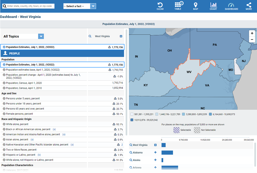
Note: The dashboard above is cropped on the bottom. Click on the image for the full dashboard.
More Stats
From data.census.gov:

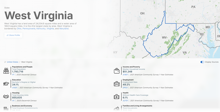
Note: The profile above is cropped at the bottom. Click on the image for the full profile.
Source: 2021 American Community Survey (ACS) 1-year estimates.
Source: U.S. Census Bureau, Population Division (Annual Estimates of the Resident Population).

Source: 2018 - 2021 Annual Survey of Manufactures (ASM).
Source: 2021 County Business Patterns (CBP).
Source: 2020 Annual Business Survey (ABS) Program.
Source: 1978-2020 Business Dynamics Statistics (BDS).
Source: 2019 Nonemployer Statistics (NES).
Source: Business Formation Statistics (BFS).
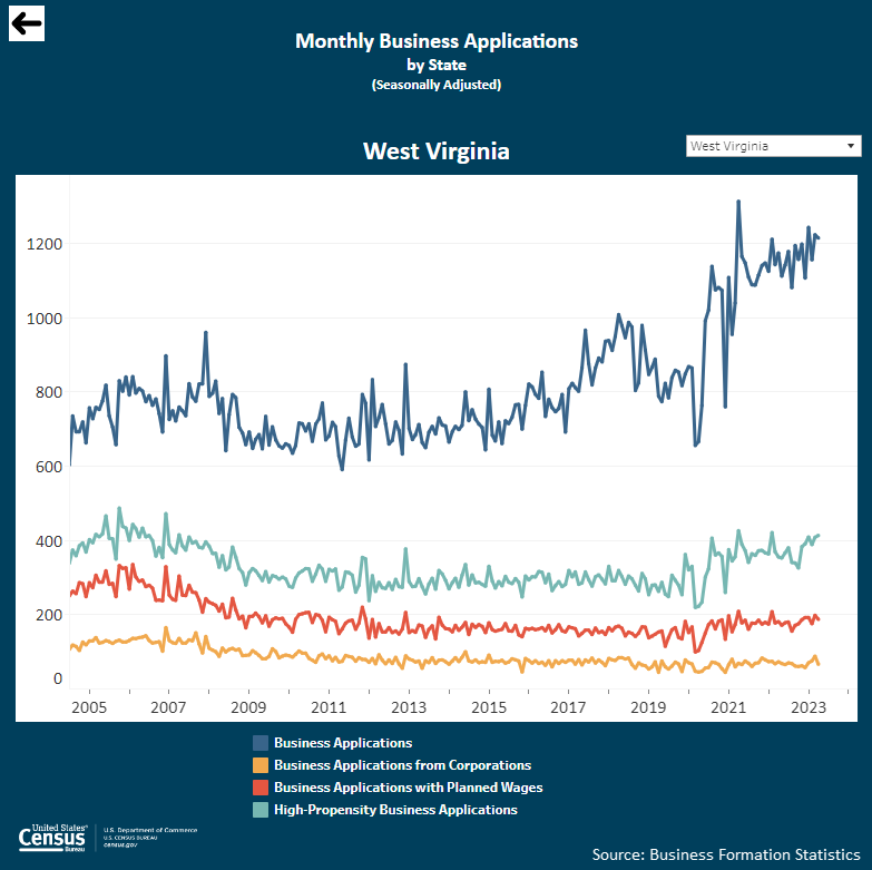
Note: Click on the image above to go to the Business Formation Statistics data page. For the West Virginia graphic, scroll down to “Interactive Graphs.” Click on the icon for “Monthly Business Applications by State (BA)” and select “West Virginia” in the upper-right drop-down area.
From Business and Economy / International Trade Data:
Note: After you create an account, you can choose between State Export Data (Origin of Movement) or State Import Data (State of Destination) by Harmonized System (HS) or NAICS. More information is available in the Quick Start Guide.
Source: Monthly State Retail Sales.
From the State Data Center (SDC) Program:
From the Library / America Counts: Stories Behind the Numbers:
From the Statistics in Schools (SIS) program:
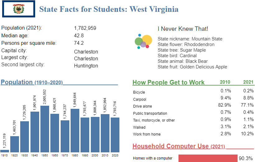
Note: The West Virginia page is cropped on the bottom. Click on the image above to go to the “State Facts for Students” main page. Use the drop down to select “West Virginia” or click “WV” on the map for the full page for West Virginia.
Source: 2017 Economic Census.
From Census.gov / History:
Outside Links
Page Last Revised - June 8, 2023
✕
Is this page helpful?
 Yes
Yes
 No
No
 Yes
Yes
 No
No✕
NO THANKS
255 characters maximum
 255 characters maximum reached
✕
Thank you for your feedback.
Comments or suggestions?

Comments or suggestions?