
Official websites use .gov
A .gov website belongs to an official government organization in the United States.
Secure .gov websites use HTTPS
A lock (
) or https:// means you’ve safely connected to the .gov website. Share sensitive information only on official, secure websites.

Topics
Data & Maps
Surveys & Programs
Resource Library
Mississippi 205th Anniversary of Statehood (1817): December 10, 2022
Mississippi 205th Anniversary of Statehood (1817): December 10, 2022
Press Release Number CB22-SFS.166
All of the area of Mississippi except the part south of the 31st parallel was included in the original territory of the United States. The United States claimed the territory south of the 31st parallel as part of the Louisiana Purchase in 1803. Mississippi Territory was organized on April 7, 1798, from unorganized area; it included area west of Georgia to the Mississippi River, comprising the southern third of the present-day states of Alabama and Mississippi. The territory annexed the northern part of the same two future states when Georgia ceded its western claims in 1802 and the lands south of the 31st parallel in 1812. Mississippi Territory was reduced by the organization of Alabama Territory in 1817. Mississippi was admitted to the Union on December 10, 1817, as the 20th state, with generally the same boundary as the present state, although jurisdiction over the entire area was not formally accomplished until Spain relinquished its claims to the southern portion of the state in 1819.

Census data for Mississippi are available beginning with the 1800 census.
Key Stats
From Census.gov / Data:

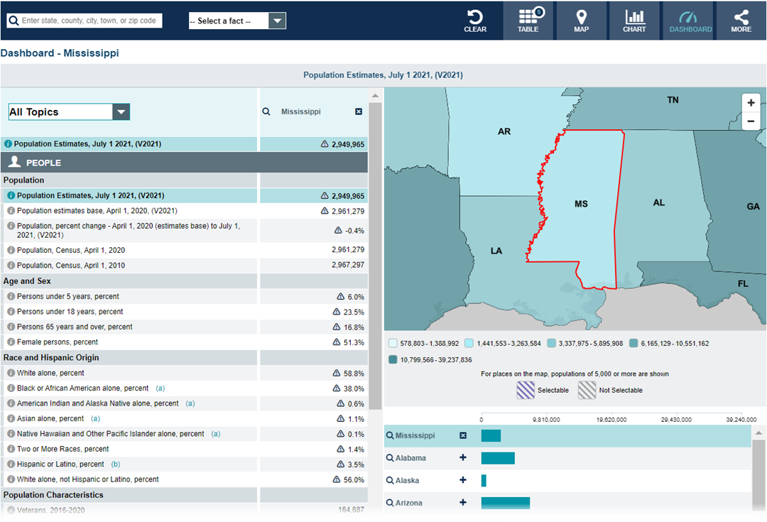
Note: The dashboard above is cropped at the bottom. Click on the image for the full dashboard.
More Stats
From data.census.gov:

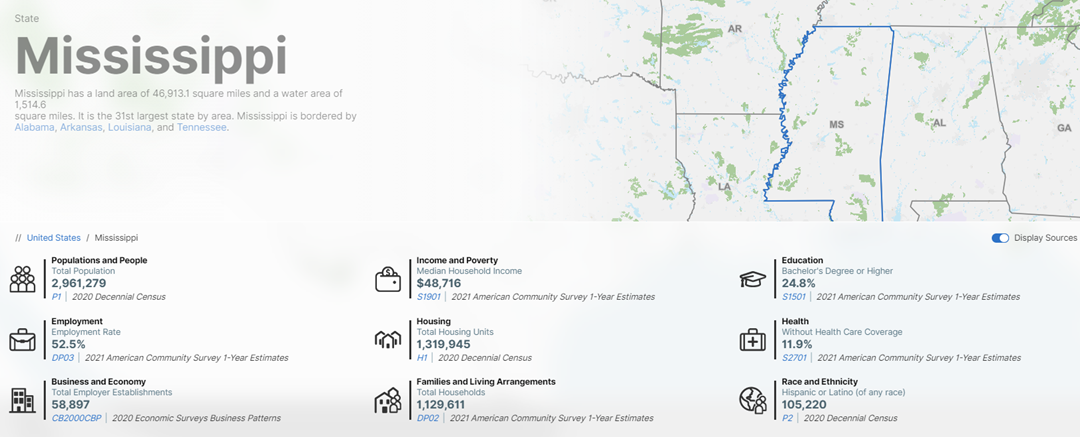
Note: The profile above is cropped at the bottom. Click on the image for the full profile.
Source: 2021 American Community Survey (ACS) 1-year estimates.
Source: U.S. Census Bureau, Population Division (Annual Estimates of the Resident Population).

Source: 2020 Annual Business Survey (ABS).
Source: 2020 Annual Survey of Manufactures (ASM).
Source: 2020 County Business Patterns (CBP).
Source: 2019 Nonemployer Statistics (NES).
Source: Business Formation Statistics (BFS).
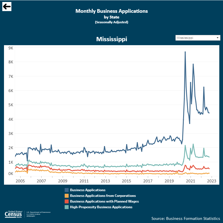
Note: Click on the image above to go to the Business Formation Statistics data page. For the Mississippi graphic, scroll down to “Interactive Graphs.” Click on the icon for “Monthly Business Applications by State (BA)” and select “Mississippi” in the upper-right drop-down area.
From Foreign Trade > U.S. International Trade Data:
Note: After you create an account, you can choose between State Export Data (Origin of Movement) or State Import Data (State of Destination) by Harmonized System (HS) or NAICS. More information is available in the Quick Start Guide.
Source: Monthly State Retail Sales.
From the State Data Center (SDC) Program:
From the Library / America Counts: Stories Behind the Numbers:
From the Statistics in Schools (SIS) program:
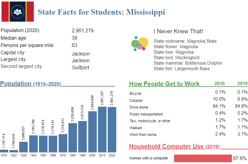
Note: The Mississippi page is cropped at the bottom. Click on the image above to go to the “State Facts for Students” main page. Then, use the drop down to select “Mississippi” or click “MS” on the map for the full page for Mississippi.
From Census.gov > History:
Outside Links
Page Last Revised - December 2, 2022
✕
Is this page helpful?
 Yes
Yes
 No
No
 Yes
Yes
 No
No✕
NO THANKS
255 characters maximum
 255 characters maximum reached
✕
Thank you for your feedback.
Comments or suggestions?

Comments or suggestions?