
Official websites use .gov
A .gov website belongs to an official government organization in the United States.
Secure .gov websites use HTTPS
A lock (
) or https:// means you’ve safely connected to the .gov website. Share sensitive information only on official, secure websites.

Topics
Data & Maps
Surveys & Programs
Resource Library

Michigan 185th Anniversary of Statehood (1837): January 26, 2022
Press Release Number CB22-SFS.09

From the Guide to 2010 State and Local Census Geography – Michigan – History:
The area of Michigan was part of the original territory of the United States, being part of lands ceded by four states to the United States and designated in 1787 as the "Territory northwest of the River Ohio." Michigan Territory was organized on June 30, 1805, from the northeastern part of Indiana Territory, and included all of the Lower Peninsula, the eastern part of the Upper Peninsula, a small strip of northern Indiana, and a portion of northwestern Ohio that was later contested. In 1818, when Illinois was admitted as a state, all of the remainder of Illinois Territory was added to Michigan Territory, including almost all of present-day Wisconsin, part of Minnesota, and the western part of the Upper Peninsula; at the same time, the central portion of the Upper Peninsula and eastern Wisconsin were added from the former Indiana Territory. In 1834, Michigan Territory was enlarged from part of Missouri Territory, including all of present-day Iowa, the remainder of Minnesota, and the eastern part of North Dakota and South Dakota. Michigan was reduced with the organization of Wisconsin Territory and the cession of the Toledo Strip to Ohio in 1836. As a compromise for the cession of territory to Ohio, Michigan Territory retained all of the Upper Peninsula when Wisconsin Territory was organized, resulting in a boundary generally the same as the present state.
Although not yet legally established as a separate territory, census data for Michigan are available beginning with the 1800 census. The 1800 census includes the population of a small area that is in present-day Ohio and excludes the population that was enumerated with Indiana of a small area of present-day Michigan. The 1800 population of the legally established Northwest Territory (of which Michigan was a part) was 45,916. The 1810, 1820, and 1830 census populations are for the entire area of Michigan Territory, including population in extensive areas not in the present state, and, in 1810, excluding again the population of a small area of present-day Michigan enumerated with Indiana. For an explanation of the revision to the 1800, 1820, and 1830 population of Michigan, see Richard L. Forstall, Population of States and Counties of the United States: 1790- 1990, Washington, DC: U.S. Government Printing Office, 1996, page 82.
Data for the legally established state of Michigan are available beginning with the 1840 census.
Key Stats
From QuickFacts: statistics for all states and counties, and for cities and towns with a population of 5,000 or more.

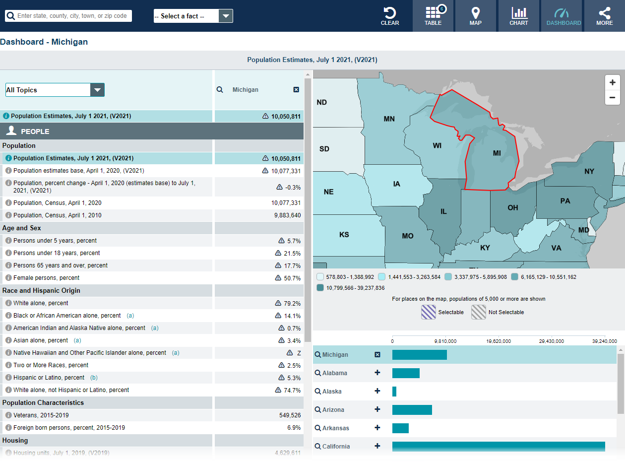
Note: The dashboard shown above is cropped at the bottom. Click on the image to see the full dashboard.
More Stats
From data.census.gov:

Note: The profile shown above is cropped at the bottom. Click on the image to see the full Profile.
Source: U.S. Census Bureau, Population Division (Annual Estimates of the Resident Population).

Source: 2019 American Community Survey (ACS) 1-Year Estimates.

Source: Business Formation Statistics (BFS).
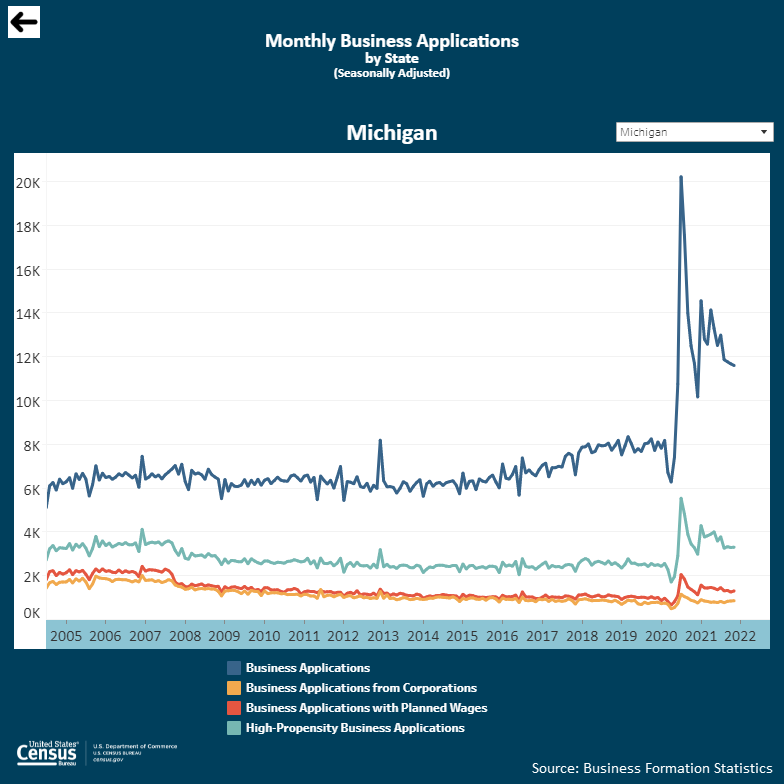
Note: Click on the image above to go to the BFS data page. To see the Michigan graphic, scroll down to “Interactive Graphs.” Click on the icon for “Monthly Business Applications by State (BA)” and select “Michigan” in the upper right drop-down area.
From Foreign Trade > U.S. International Trade Data:
Note: After you create an account, you can choose between State Export Data (Origin of Movement) or State Import Data (State of Destination) by Harmonized System (HS) or NAICS. More information is available in the Quick Start Guide.
Source: Monthly State Retail Sales (Select Michigan).
From the State Data Center (SDC) Program:
From Census Bureau History:
From the Library > America Counts: Stories Behind the Numbers:
From the Statistics in Schools (SIS) program:
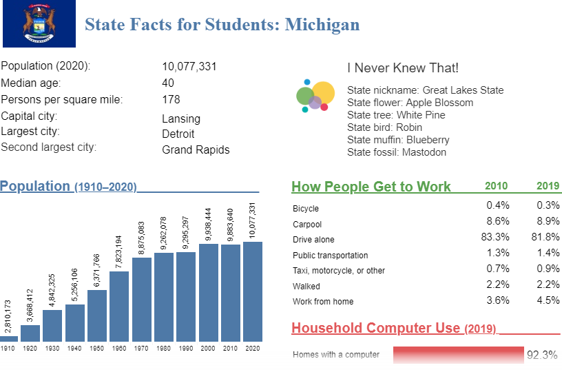
Note: The Michigan page is cropped at the bottom. Click on the image above to go to the “State Facts for Students” main page. Then, use the drop down to select “Michigan” or click “MI” on the map to see the full page for Michigan.
Page Last Revised - January 18, 2022
✕
Is this page helpful?
 Yes
Yes
 No
No
 Yes
Yes
 No
No✕
NO THANKS
255 characters maximum
 255 characters maximum reached
✕
Thank you for your feedback.
Comments or suggestions?

Comments or suggestions?