
Official websites use .gov
A .gov website belongs to an official government organization in the United States.
Secure .gov websites use HTTPS
A lock (
) or https:// means you’ve safely connected to the .gov website. Share sensitive information only on official, secure websites.

Topics
Data & Maps
Surveys & Programs
Resource Library
Connecticut 235th Anniversary of Statehood (1788): January 9, 2023
Connecticut 235th Anniversary of Statehood (1788): January 9, 2023
Press Release Number CB23-SFS.005
The area of Connecticut was part of the original territory of the United States. It was chartered as a colony in 1662. In 1786, it ceded area to the United States’ government that became part of the Northwest Territory in 1787. Connecticut ratified the U.S. Constitution on January 9, 1788; it was the fifth of the original 13 states to join the Union. Its boundary was generally the same as the present state (excluding the Connecticut Western Reserve), although the boundary between Connecticut and Massachusetts was changed slightly in 1804.

Census data for Connecticut are available beginning with the 1790 census.
From the Federal Register: A Notice by the Census Bureau on 06/06/2022:
“SUMMARY: This notice provides information about the State of Connecticut's (hereafter Connecticut or the State) formal request to the Census Bureau to adopt the State's nine planning regions as county-equivalent geographic units for purposes of collecting, tabulating, and disseminating statistical data, replacing the eight counties which ceased to function as governmental and administrative entities in 1960. The Census Bureau will implement this change internally in 2022, with public data and geospatial products reflecting the change beginning in late 2022. By 2024, all Census Bureau operations and publications, both internal and external, will use the nine new county-equivalent boundaries, names, and codes, except for 2020 Decennial Census data publications and other datasets referencing the eight legacy counties as published before June 1, 2022.”
Key Stats
From Census.gov / Data:

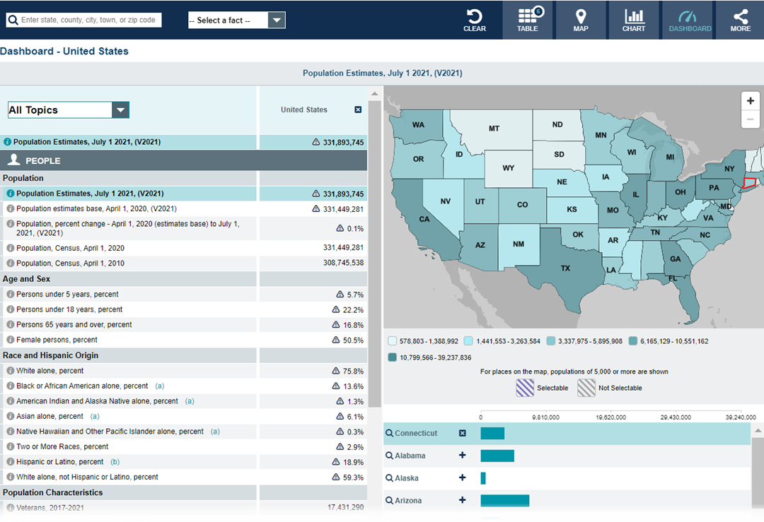
Note: The dashboard above is cropped at the bottom. Click on the image for the full dashboard.
More Stats
From data.census.gov:
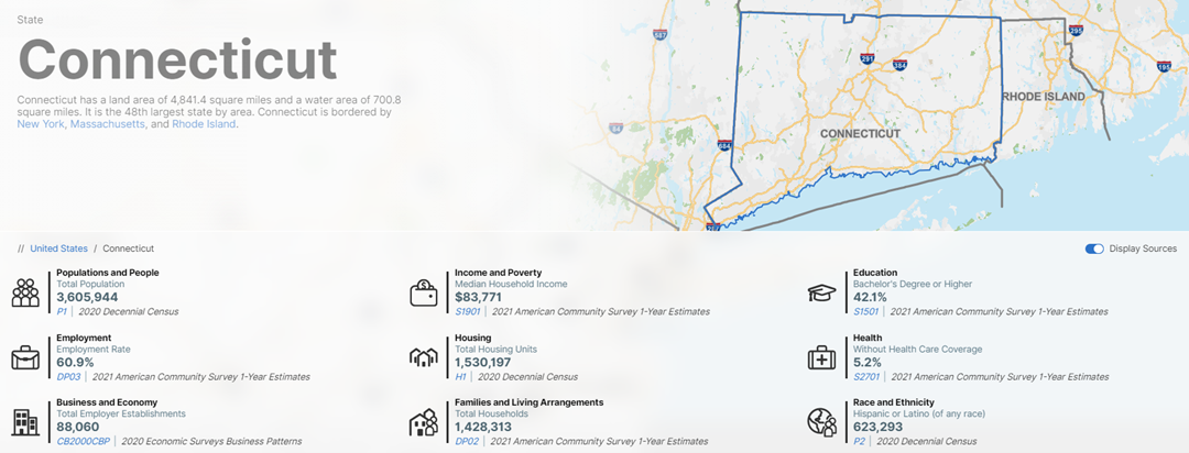
Note: The profile above is cropped at the bottom. Click on the image for the full profile.
Source: 2021 American Community Survey (ACS) 1-year estimates.

Source: U.S. Census Bureau, Population Division (Annual Estimates of the Resident Population).

Source: 2018 - 2021 Annual Survey of Manufactures (ASM).
Source: 2020 Annual Business Survey (ABS).
Source: 2020 County Business Patterns (CBP).
Source: 2019 Nonemployer Statistics (NES).
Source: Business Formation Statistics (BFS).
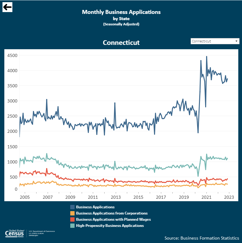
Note: Click on the image above to go to the Business Formation Statistics data page. For the Connecticut graphic, scroll down to “Interactive Graphs.” Click on the icon for “Monthly Business Applications by State (BA)” and select “Connecticut” in the upper-right drop-down area.
From Foreign Trade > International Trade Data:
Note: After you create an account, you can choose between State Export Data (Origin of Movement) or State Import Data (State of Destination) by Harmonized System (HS) or NAICS. More information is available in the Quick Start Guide.
Source: Monthly State Retail Sales.
From the State Data Center (SDC) Program:
From the Library / America Counts: Stories Behind the Numbers:
From the Statistics in Schools (SIS) program:
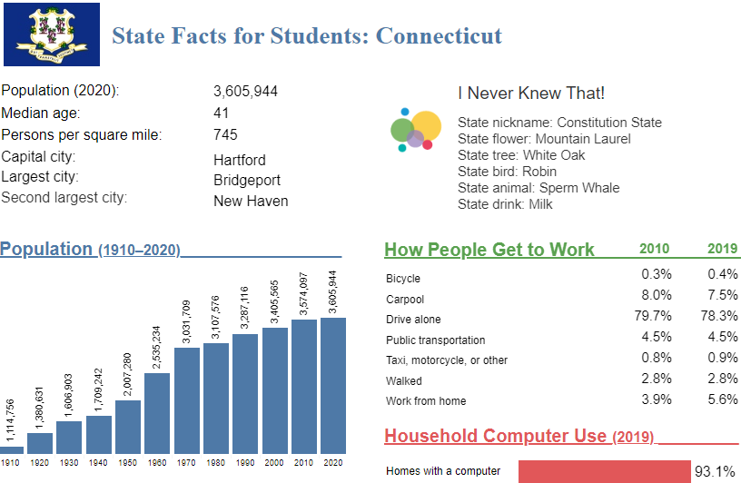
Note: The Connecticut page is cropped at the bottom. Click on the image above to go to the “State Facts for Students” main page. Then, use the drop down to select “Connecticut” or click “CT” on the map for the full page for Connecticut.
Source: 2017 Economic Census.
From Census.gov > History:
Outside Links
Page Last Revised - December 22, 2022
✕
Is this page helpful?
 Yes
Yes
 No
No
 Yes
Yes
 No
No✕
NO THANKS
255 characters maximum
 255 characters maximum reached
✕
Thank you for your feedback.
Comments or suggestions?

Comments or suggestions?