For Immediate Release: Friday, August 09, 2024
Census Bureau Data Highlights Vulnerable Populations Exposed to Hurricane Debby
Hurricane Debby made landfall as a Category 1 (74-95 miles per hour) hurricane in the Big Bend region of Florida at 7 a.m. EDT Monday, August 5, and is currently moving slowly through Florida and Georgia as a tropical storm. Debby has already produced dangerous winds and storm surge, and it is forecasted to produce near-historic levels of rainfall and flash flooding risk as it makes its way through Georgia and the Carolinas. What can we say about the people who are being exposed to these hazards? The Census Bureau’s data on the U.S. population puts it in a unique position to analyze the characteristics of the exposed population in close to real-time.
To conduct this analysis, we need timely information on population characteristics in a format that can be easily combined with geospatial information published by the National Hurricane Center. This is made possible by the prototype gridded Environmental Impacts Frame. The Environmental Impacts Frame (EIF) is a confidential microdata infrastructure developed by the U.S. Census Bureau that combines residential and demographic information from administrative records (including data from tax returns, Medicare participation, Census Bureau collected data, and the U.S. Postal Service) and surveys with geospatial information on environmental hazards. As part of this research project, the Census Bureau has developed a privacy-protected gridded dataset that provides information on the population within 0.01 degree grid cells (about 1 km) by race/ethnicity, age, sex and income, using the most up-to-date information available from linked administrative records on individuals’ locations.

Source: Gridded Environmental Impacts Frame and National Hurricane Center data
We combine this information with the geospatial data on dangerous winds and flooding risks due to extreme rainfall provided by the National Hurricane Center. This allows us to explore the demographics of individuals exposed to each of the hazards associated with Debby and understand how these exposed populations differ from the overall U.S. population.
Socioeconomic Characteristics of the Population Forecasted to be Exposed to Tropical Storm Force Winds Through August 6
| Population | Percent | National percent | Difference from national | |
|---|---|---|---|---|
| Non-Hispanic White | 2,290,973 | 58.84 | 55.03 | 3.81 |
| Non-Hispanic Black | 1,026,133 | 26.35 | 11.60 | 14.75 |
| Hispanic | 207,073 | 5.32 | 15.80 | -10.48 |
| Non-Hispanic Asian | 45,591 | 1.17 | 4.13 | -2.96 |
| Over the age of 65 | 857,294 | 22.02 | 18.26 | 3.76 |
| Under the age of 18 | 726,835 | 18.67 | 19.69 | -1.02 |
| Low income | 966,918 | 24.83 | 20.02 | 4.81 |
| Total Population exposed | 3,893,777 | |||
Source: Gridded Environmental Impacts Frame and National Hurricane Center data
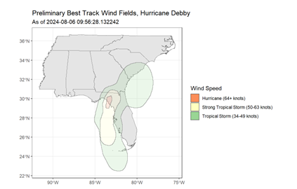
First, we consider the impact of dangerous winds. As noted, Debby made landfall as a Category 1 hurricane, exposing a relatively small area in Florida to hurricane force winds. However, a much broader area of Florida and Georgia has been exposed to tropical storm force winds. Table 1 summarizes the characteristics of all those who were exposed to at least tropical storm force winds; Table 2 summarizes information for those exposed to more dangerous hurricane force winds.
Socioeconomic Characteristics of the Population Exposed to Hurricane Force Winds Through August 6
| Population | Percent | National percent | Difference from national | |
|---|---|---|---|---|
| Non-Hispanic White | 18,230 | 75.82 | 55.03 | 20.79 |
| Non-Hispanic Black | 2,042 | 8.49 | 11.60 | -3.11 |
| Hispanic | 1,634 | 6.80 | 15.80 | -9.00 |
| Non-Hispanic Asian | 138 | 0.57 | 4.13 | -3.56 |
| Over the age of 65 | 5,772 | 24.01 | 18.26 | 5.75 |
| Under the age of 18 | 5,150 | 21.42 | 19.69 | 1.73 |
| Low income | 7,919 | 33.99 | 20.02 | 13.97 |
| Total Population exposed | 24,044 | |||
Source: Gridded Environmental Impacts Frame and National Hurricane Center data
Around 11.5 million individuals have been exposed to at least tropical storm force winds, while around 24,000 were exposed to hurricane force winds. Overall, individuals exposed to tropical storm force or hurricane force winds were more likely to be elderly, more likely to be low income relative to the national population. This was especially pronounced for those exposed to hurricane force winds – for instance, those exposed to hurricane force winds are almost 14 percentage points more likely to be low income (defined as being in the bottom quintile of the national income distribution) than the overall U.S. population.

Source: Gridded Environmental Impacts Frame and National Hurricane Center data
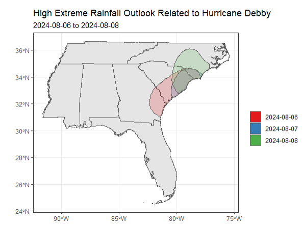
We next turn to hazards related to extreme rainfall. Over the period of August 6-8, large parts of the coasts of Georgia and the Carolinas were expected to receive extreme amounts of rainfall. Figure 2 shows the areas with the highest risk of flash flooding due to extreme rainfall by the National Weather Service. Much of these areas were forecast to receive at least 10 inches of rain, with some locations forecast to receive 15 inches or more.
Socioeconomic Characteristics of the Population Exposed to High Extreme Rainfall Outlook, August 6 through August 8
| Population | Percent | National percent | Difference from national | |
|---|---|---|---|---|
| Non-Hispanic White | 3,781,256 | 56.01 | 55.03 | 0.98 |
| Non-Hispanic Black | 1,602,936 | 23.74 | 11.60 | 12.14 |
| Hispanic | 459,509 | 6.81 | 15.80 | -8.99 |
| Non-Hispanic Asian | 131,655 | 1.95 | 4.13 | -2.18 |
| Over the age of 65 | 1,253,895 | 18.57 | 18.26 | 0.31 |
| Under the age of 18 | 1,366,180 | 20.24 | 19.69 | 0.55 |
| Low income | 1,569,401 | 23.27 | 20.02 | 3.25 |
| Total Population exposed | 6,751,112 | |||
Source: Gridded Environmental Impacts Frame and National Hurricane Center data
It was forecasted that around 6.75 million people would be exposed to these extreme rainfall-related flooding risks. These individuals are much more likely than the total U.S. population to be non-Hispanic Black and somewhat more likely to be low income. Understanding the characteristics of populations exposed to environmental hazards, such as Debby’s dangerous winds and flooding risks, is crucial to assessing the full impact of such events. This knowledge, particularly regarding the vulnerability and number of exposed individuals, provides valuable information for policymakers as they respond to natural disasters like hurricanes. As this brief analysis has shown, these characteristics can vary widely even among different hazards related to the same event. The EIF, which leverages the most recent information on individuals’ characteristics and locations, serves as a powerful platform for this type of rapid response analysis. Note that while the EIF uses the most up-to-date information available in administrative records, this information nonetheless may be several months old. By leveraging this tool, we can enhance our ability to target relief efforts and allocate resources more effectively, ultimately improving our disaster response and resilience strategies.
Plans are to eventually make the confidential EIF microdata (used to create the gridded EIF) available to qualified researchers on approved projects through the Federal Statistical Research Data Centers, a network of 31 secure physical locations. These research activities may help uncover new uses for the EIF and lead to improvements in the underlying data and associated information products. This continual feedback loop helps the Census Bureau to produce timely and relevant information for our many stakeholders.


