An official website of the United States government
Here’s how you know
Official websites use .gov
A .gov website belongs to an official government organization in the United States.
Secure .gov websites use HTTPS
A lock (
) or https:// means you’ve safely connected to the .gov website. Share sensitive information only on official, secure websites.
-
//
- Census.gov /
- Census Blogs /
- Research Matters /
- Identifying Hard-to-Survey Populations Using Low Response Scores by Census Tract
Identifying Hard-to-Survey Populations Using Low Response Scores by Census Tract
Identifying Hard-to-Survey Populations Using Low Response Scores by Census Tract
The U.S. Census Bureau’s Planning Database is a publicly available data set derived from the 2009-2013 American Community Survey (ACS) and 2010 Census data. It has many potential uses not just for survey practitioners, but for local governments and planners as well. It can be used to locate tracts or block groups with characteristics of interest (e.g. seniors, children, Hispanics, languages spoken, poverty rates, health insurance coverage rates, etc.) to inform sample design and the allocation of financial resources. Additionally, users can employ the planning database to provide information about a target population, create geographic information systems (GIS) maps, enhance reports and construct models.
Unlike the ACS summary files, the Planning Database only contains the “greatest hits” of ACS variables such as age, gender, race and languages spoken at the tract and block group level, so it is a smaller, more manageable file for users of all experience levels. It also contains derived percentages and their margins of error.
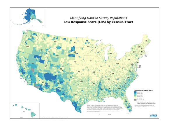
In addition to the ACS five-year estimates and 2010 Census data, the Planning Database has a variable called the Low Response Score (LRS) [PDF]. This score is a block group or tract’s mail nonresponse rate. Similar to the Census Bureau’s Hard to Count Score [PDF], the LRS allows us to identify areas likely to need additional targeted marketing and field follow-up.
While the current Planning Database is ideal for users who need tract or block group level data, there are instances when practitioners need information at other geographic levels, such as ZIP code. While ZIP code does not perfectly map to census geography, the Census Bureau has created the ZIP Code Tabulation Areas (ZCTA) that can be linked to tracts.
At the 2016 American Association for Public Opinion Research conference, we will highlight the current tract and block group Planning Database, compare the distribution of Planning Database variables between two geographies (ZCTA and tract), and provide a demonstration of how to create a customized Planning Database at the ZCTA and potentially other levels of geography.
Share
 Yes
Yes
 No
NoComments or suggestions?


Top

