Understanding Geographic Relationships: American Indian Areas
Understanding Geographic Relationships: American Indian Areas
Part two in the Understanding Geographic Relationships series focuses on relationships that exist between different types of American Indian Areas. Part one in this series provided an overview of how Census Bureau geographies relate to one another.
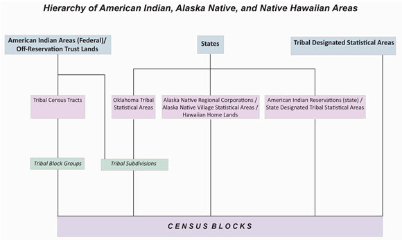
The Hierarchy of American Indian, Alaska Native, and Native Hawaiian Areas [PDF <1.0 MB] displays the relationship between both legal and statistical American Indian Area boundaries. The hierarchy portrays relationships with a line and shows where relationships do not exist by displaying entities on different line tracks. For example, you can see how tribal census tracts and tribal block groups are related.
It is important to note that the only entities on the American Indian Area hierarchy that are also on the standard hierarchy [PDF <1.0 MB] are states and census blocks. These are the only two standard geographic units that have a relationship with American Indian Area geographic units.
Federal American Indian Areas and off-reservation trust lands do not need to fall with any other geography like states or counties. In fact, they often cross stae and county lines. In 2010, there were 311 reservations and all are on the same level as the nation on the standard hierarchy.
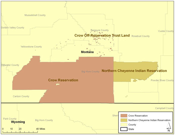
Here is an example of federal American Indian Areas with trust lands.
Federal American Indian Areas can be divided into four other geographic entities, including tribal subdivisions, tribal census tracts, tribal block groups and census blocks.
- Tribal subdivisions split a reservation and its trust lands into areas such as communities, chapters, districts and administrative areas. It is up to each tribal government whether it delineates subdivisions in order to receive data for these areas, which are smaller than the reservation boundary. Currently, 24 federal American Indian Areas contain tribal subdivisions.
- All federal American Indian Areas with land contain tribal census tracts. Tribal census tracts must fall within the reservation boundary but do not need to coincide within any other geography and are delineated separately than the standard state-county census tracts. In addition, they may be discontinuous in order to cover off-reservation trust lands. Tribal census tracts are based on population, so smaller reservations may only have one tribal census tract.
- All federal American Indian Areas with land also contain tribal block groups, although smaller populated reservations may only have one. Tribal block groups must fall within tribal census tracts and are delineated separately than the standard state-county block groups. They may also be discontinuous to include off-reservation trust lands.
- Census blocks fall within everything. Just like in the standard hierarchy, census blocks are the building blocks for all American Indian Areas.
Moving across the hierarchy, another American Indian Area entity that does not fall within any other geography is the Tribal Designated Statistical Area (TDSA). TSDAs are statistical areas for federally recognized tribes that do not have a federally recognized land base. The only other geographic unit that falls within a TDSA is the census blocks.
Finally, three entities on the hierarchy must stay within state boundaries.
- Oklahoma Tribal Statistical Areas (OTSAs) fall within the state of Oklahoma. Similar to federal American Indian Areas, OTSAs can be divided into tribal subdivisions, although not all OTSAs are. Subdivisions must stay within each OTSA. Census blocks must also stay within each OTSA.
- Alaska Native Regional Corporations, Alaska Native Village Statistical Areas, and Hawaiian Home Lands must fall within their respective states (Alaska or Hawaii). Census blocks are the only geography that fall within each area.
- State American Indian Reservations and State Designated Tribal Statistical Areas must also stay within their respective state boundary and have census blocks that fall within them. Not every state contains these areas. In 2013, six states have state American Indian Reservations and six states have state designated tribal statistical areas.
The hierarchy provides a quick and easy way for data users to see how the different American Indian Areas relate to one another. It is important to understand the hierarchy to get to the correct data. The next Understanding Geographic Relationships post will shed some light on summary levels and their role in accessing different geographic relationships in American FactFinder.
It is the 25 year anniversary of the TIGER (Topologically Integrated Geographic Encoding and Referencing) database. Stay tuned for more on this important milestone in geographic history.


