How Do We Measure Urban Areas?
How Do We Measure Urban Areas?
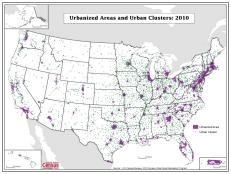
If you have looked out the window of a plane while flying over the United States, you no doubt have seen areas that are clearly built-up and densely settled and areas that are not. The extent of each built-up area varies, but each is distinguishable from the surrounding less developed territory.
When we look at results from the 2010 Census, we not only see demographic changes in our population, but also geographic ones.
Throughout much of the nation, individual urban areas are clearly distinguished; however, in some areas, such as the heavily developed Northeast, one urban area flows into another, and determining the boundary between individual urban areas becomes difficult.
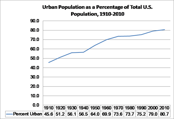
Starting with the 1910 Census, the Census Bureau has defined urban areas of at least 2,500 people (“rural” encompasses the territory outside urban areas) to provide the nation with information about our urban and rural population, housing, and land area. Over the course of a century, we have charted our growth from a mostly rural nation, to one that is predominantly urban.
Results from the 2010 Census show us that the nation’s urban population increased by 12.1 percent from 2000 to 2010, outpacing the nation’s overall growth rate of 9.7 percent for the same period.
The Census Bureau currently identifies two types of urban areas: urbanized areas of 50,000 or more people, and urban clusters of at least 2,500 and less than 50,000 people, both representing densely developed territory and encompassing residential, commercial, and other non-residential urban land uses. Together these provide a nationally consistent classification for researchers, analysts, and policy makers.
However, how we define urban areas has changed over time, as the nation’s settlement patterns have changed. From 1910 through 1940, we generally limited our urban definition to incorporated places of 2,500 or more people. City and town boundaries closely matched the extent of built-up areas, so that definition was adequate, although not completely accurate. In 1950, in response to increasing suburban development, we began defining urbanized areas of 50,000 or more people. Outside urbanized areas, we still identified urban places of 2,500 or more people.
As we moved toward Census 2000, it was clear that substantial built-up areas also existed on the fringes of smaller cities and towns, and that our urban definition did not adequately reflect the distribution of densely settled populations. We introduced urban clusters of 2,500 and less than 50,000 people for Census 2000, resulting in our current classification.
For the 2010 Census, we used national land use and land cover data to enhance our ability to account for non-residential urban land uses and improve our delineation of urban areas. By consistently updating our methods, we are better able to measure America’s places.
For more information about the Census Bureau’s urban areas and our urban-rural classification for the 2010 Census, see our website.


