An official website of the United States government
Here’s how you know
Official websites use .gov
A .gov website belongs to an official government organization in the United States.
Secure .gov websites use HTTPS
A lock (
) or https:// means you’ve safely connected to the .gov website. Share sensitive information only on official, secure websites.
-
//
- Census.gov /
- Census Blogs /
- Random Samplings /
- Visualizing Data with OnTheMap for Emergency Management
Visualizing Data with OnTheMap for Emergency Management
Visualizing Data with OnTheMap for Emergency Management
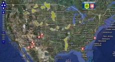
The Census Bureau released OnTheMap for Emergency Management Version 2.0 today, the beginning of the 2011 hurricane season. Version 2.0 adds floods and wildfires to hurricanes which was released last year.
OnTheMap for Emergency Management is a public data tool that provides unique detail on the workforce, for U.S. areas affected by hurricanes, floods, and wildfires, in real time. The web-based tool provides an intuitive interface for viewing the location and extent of current and forecasted emergency events on a map, and allows users to easily retrieve detailed reports containing labor market characteristics for these areas. The reports provide the number and location of jobs, industry type, worker age and earnings. Worker race, ethnicity, and educational attainment levels are under a beta release at this time.
- Real Time Updates for Hurricanes, Floods and Wildfires
- Expanded Hurricane Detail (Forecast Area, Current Wind Radii, Wind History)
- Expanded Reports with New Beta Data on Demographic Characteristics (Race, Ethnicity, Educational Attainment)
- Improved User Interface with New Map, Navigation, and Search Tools Map
- Animation & Timeline for Viewing Daily Event Histories
OnTheMap for Emergency Management Version 2.0 can be accessed by selecting “Local Employment Dynamics” at //www.census.gov and then OnTheMap for Emergency Management under Quick Links, or directly at //lehdmap.did.census.gov/em.html.
Share
 Yes
Yes
 No
NoComments or suggestions?


Top

