
Job Sprawl Results in Unemployment for Low-Income Urban Residents
When jobs are far from where the people who need them live, unemployment rates climb.
Job sprawl to the suburbs has created a commuting challenge that hits low-income residents the hardest. Many may not be able to afford a car and if access to public transportation is limited, those living in cities cannot take advantage of job opportunities in suburbs miles away.
Economists call the gap between where the jobs are and where people live “spatial mismatch,” which can cause high unemployment and longer spells of joblessness for low-income populations.
Many may not be able to afford a car and if access to public transportation is limited, those living in cities cannot take advantage of job opportunities in suburbs miles away.
The U.S. Census Bureau recently explored the challenge of matching jobs and workers during a Local Employment Dynamics (LED) webinar, “Job Growth and Spatial Mismatch Between Jobs and Low-Income Residents.”
During the webinar, Reza Sardari, a GIS (Geographic Information Systems) analyst with a decade of local government and land-use transportation planning, shared his research on job sprawl in the Dallas-Fort Worth region. Sardari is the traffic and revenue analyst at Austin-based Cintra, a private sector transportation infrastructure company.
Using data provided by the LEHD Origin-Destination Employee Statistics or LODES, Sardari showed the divide between low-income families and suburban job opportunities.
LODES shows the relationship between where people work and where they live in cities across the country.
Spatial Mismatch in the Dallas Area
In 1990, the population in the Dallas-Fort Worth area was about 3 million with employment at 2 million. More than 25 years later, the population had more than doubled to 7.4 million and employment was 3.6 million.
By 2018, Dallas-Fort Worth’s population had increased the most of any metro area, according to Census Bureau estimates.

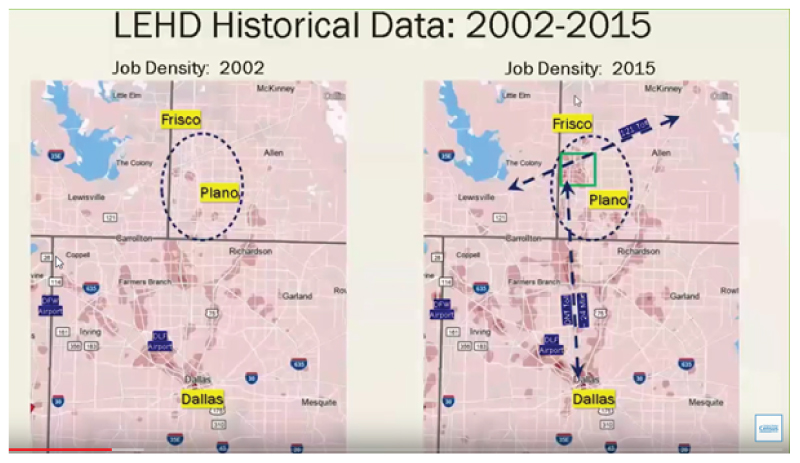
Sardari captured job growth in the Dallas metro area over the past 13 years with data from OnTheMap, a Census Bureau online mapping and reporting application.
The 2015 map shows growth in low-wage jobs about 25 miles away from downtown Dallas, to the north of the city. Many corporate headquarters, such as Toyota and Ikea, have relocated or expanded their operations there.
The main access between north and south for commuters is the Dallas North Tollway. Average travel time during peak rush hours is two hours by public transit or 45 minutes by car, with estimated yearly toll fees ranging from $175-$3,289.
“The key point to analyzing spatial inequality is where low-wage workers are located, along with identifying minorities and low-income families,” Sardari said.
OnTheMap pinpoints where workers live, along with demographic details such as race, ethnicity, gender and other socioeconomic factors.
The Home Area Profile analysis showed a higher concentration of low-wage-workers living in the southern part of Dallas. It revealed that new job opportunities were far from low-income families who lived in subsidized housing in the southern section of the city.
Residence Area Characteristic data, which include total jobs by census blocks of where workers live, show the income and race of workers.

Location affordability is also a key factor. According to a housing and transportation cost index by the Center for Neighborhood Technology, an area is “affordable” if workers’ housing and transportation costs are no more than 45% of their income.
According to a 2018 article in the Texas Tribune, suburbs to the north of Dallas are not “affordable.” Rent and housing is high and public transportation is limited.
Visualizing Spatial Mismatch
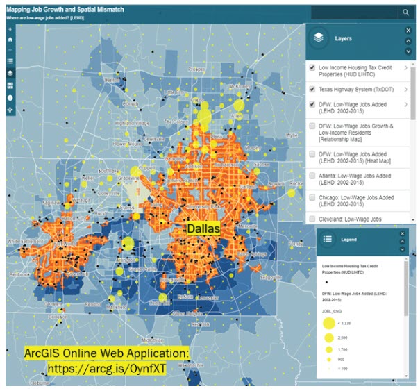
Sardari developed a data integration map that allows overlapping and integrating of all factors that play a role in spatial mismatch (see below).
He combined mapping applications with data from LODES, the American Community Survey, Department of Housing and Urban Development, Low-Income Housing Tax Credits and General Transit Feed Specification to create a visualization of jobs moving to the northern sector of the Dallas metro area.
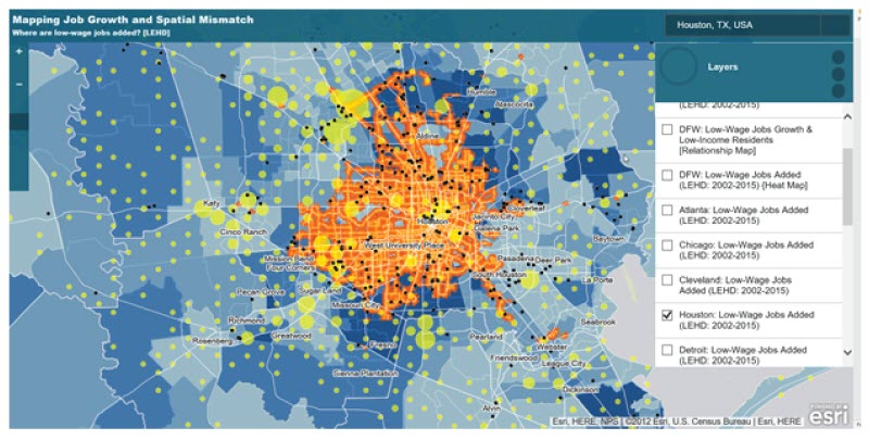
Sardari also studied the Houston area to locate low-income jobs, subsidized properties from HUD and low-wage jobs in that metropolitan area using the LEHD 2002-2015 data.
The map above of Houston shows similar findings as in the Dallas area of jobs moving to the suburbs. Visit arcg.is to explore other metro areas.
LODES captures four main components of spatial mismatch — job location, accessibility, home location, affordability — through the work and resident area characteristics it provides.
By looking at different variables, decision makers and planners can track job changes over time, Sardari said, and “consider different solutions to fill the gap between jobs and low-income residents.”
Earlene K.P. Dowell is a program analyst in the Census Bureau's Data Users Trade and Outreach Branch.
Subscribe
Our email newsletter is sent out on the day we publish a story. Get an alert directly in your inbox to read, share and blog about our newest stories.
Contact our Public Information Office for media inquiries or interviews.
-
America Counts StoryCensus Innovative LEHD Program on Local Workforce Dynamics Turns 20January 15, 2020The LEHD program began as a small startup. It grew into regularly published national statistics on worker and job flows at no cost to state partners.
-
America Counts StoryNew Census Bureau Tool Illustrates Job-to-Job FlowsJanuary 08, 2020Local data on hiring shows how construction firms are growing their workforce.
-
America Counts StoryEffects of Economic Downturn on Private and Public EmploymentOctober 17, 2019Private industry employment dipped more but rebounded quicker, surpassing pre-recession levels. Public sector employment still has not fully recovered.
-
PopulationSome Like it Hot: County Domestic Migration Trends From 2011 to 2025March 26, 2026Counties that once attracted droves of domestic migrants have cooled off and other counties have replaced them as popular migration destinations.
-
PopulationNet International Migration Down in Every State and Most CountiesMarch 26, 2026Census Bureau used new methodology to improve accuracy of county population estimates released today.
-
Business and EconomyU.S. Chemical Manufacturers Grew Despite Overall Manufacturing DeclineMarch 05, 2026The chemical manufacturing industry creates commonplace products like medicine, soap and plastics.
-
Income and PovertyMany U.S. Counties Had High Poverty Rates Over 20 YearsFebruary 26, 2026Recently released 2024 American Community Survey 5-year data identify places where poverty rates were consistently high since 2005.