
Official websites use .gov
A .gov website belongs to an official government organization in the United States.
Secure .gov websites use HTTPS
A lock (
) or https:// means you’ve safely connected to the .gov website. Share sensitive information only on official, secure websites.

data.census.gov Updates
On January 26, we released the following updates to the site:
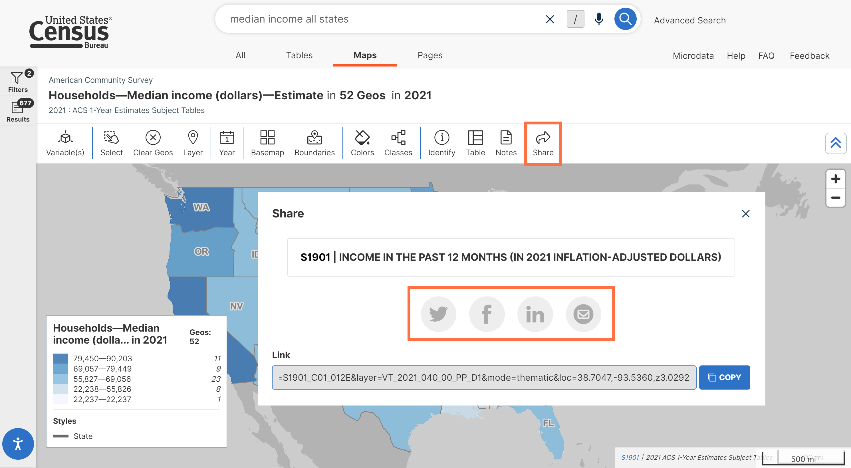
- New buttons that allow you share data.census.gov content directly via social media (Twitter, Facebook, LinkedIn) and email. This feature allows you to share any table, map, or profile at the click of a button. You may also share an individual chart or population pyramid within a profile.
We applied this feature to all pre-existing share buttons, and we also added new share buttons to our maps and profiles with this release.
- Behind the scenes technical improvements to:
- Help external search engines better understand and link to data.census.gov content
- Reduce load times for long lists
- Support our ability to provide simpler hierarchical displays in the future
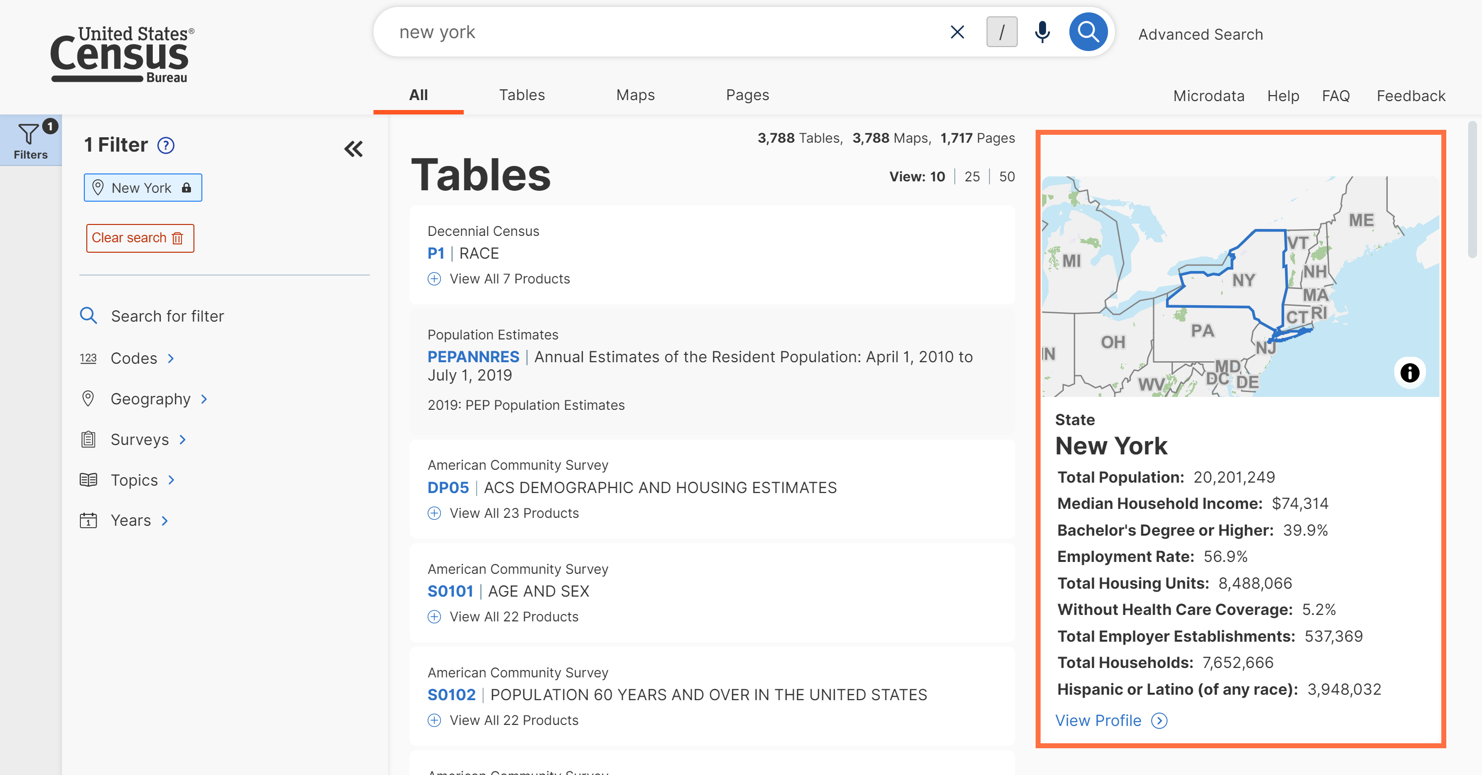
- Enhanced summary text for profiles on the All Results page. With this update, we added highlighted data directly to the All Results page. This provides popular statistics at-a-glance and gives you more detail about the type of information you can explore by opening the profile.
- Fixes to 5 defects, including fixes that allow you to:
- Return to the default view of the geography filter panel after closing and re-opening it
- See all relevant variables in the Microdata Access Tool after selecting a topic filter
On February 23, we released the following updates to the site:
- Fixes to 19 defects, including fixes that allow you to:
- View labels for the correct congressional district vintage
- Download tables for iterated products that match your population group and geography selections
- Download large tables from the Post-Secondary Employment Outcomes (PSEO) program
- Experience intuitive responses when navigating through filter panels in the advanced search. Any click that opens a new panel will take you to the top of the list. Any click to select a check box for your search criteria will keep you in the current view.
On March 16, we released the following updates to the site:
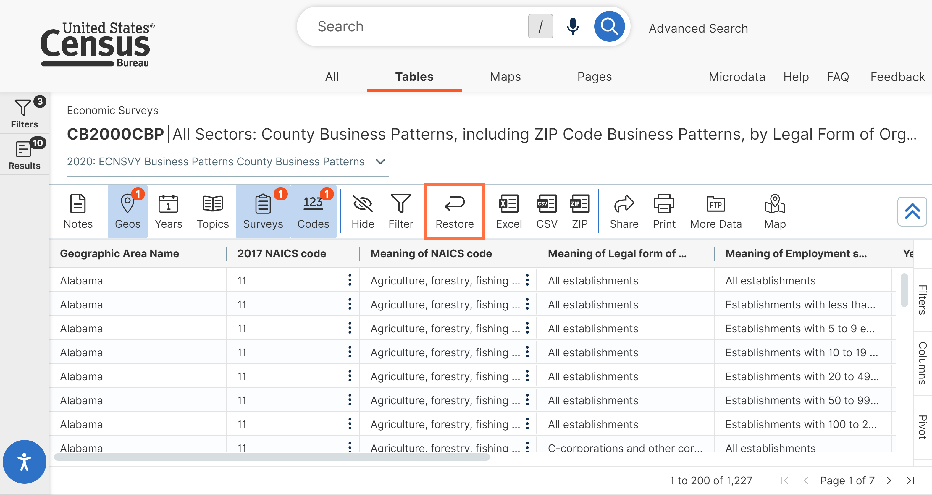
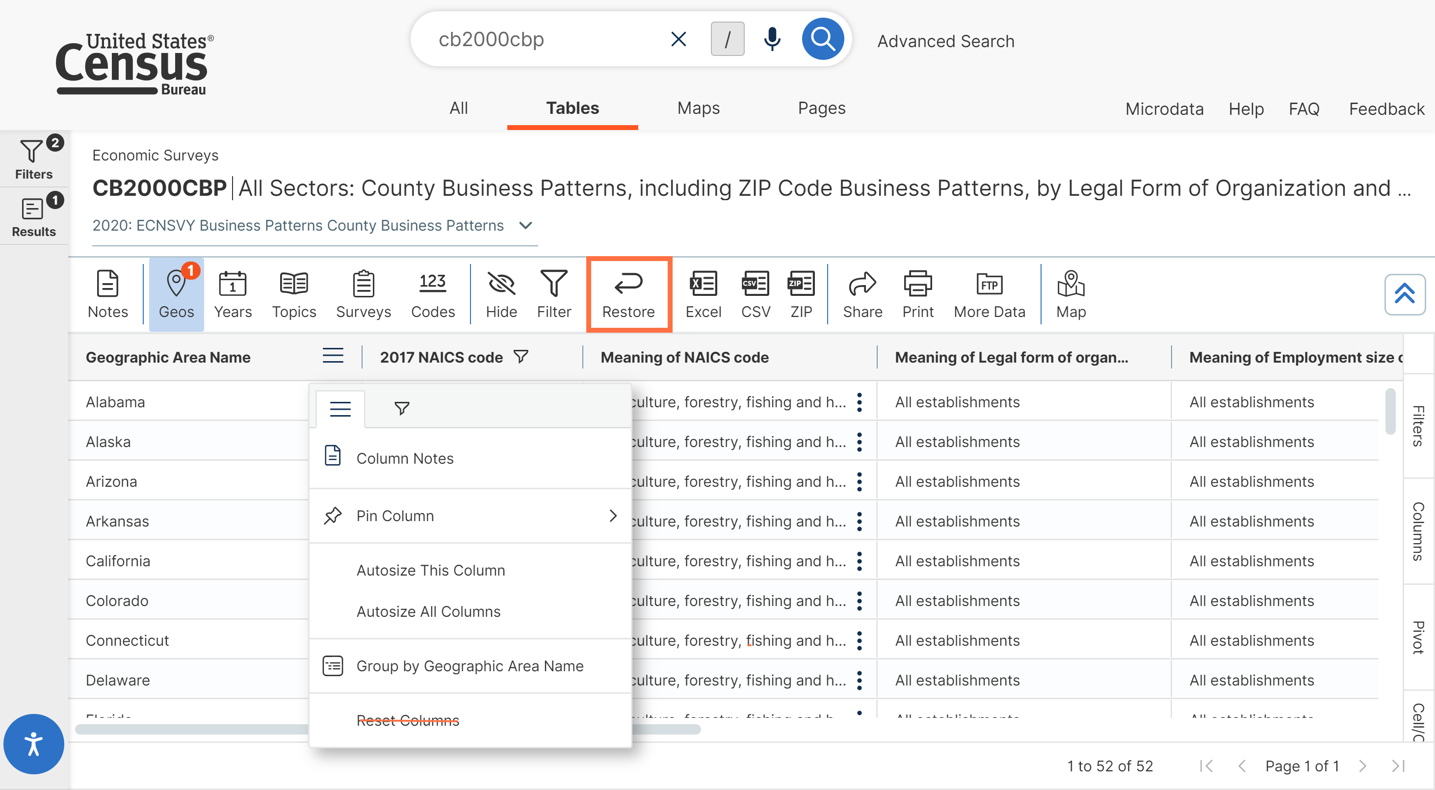
- Expanded functionality to restore the table back to the default view. When you click the Restore button at the top of the table, it will clear any custom filters you applied to the columns of the table and return to the original view.
- Behind-the-scenes technical updates to support future improvements to the single search. Specifically, this work is designed to support future enhancements to your experience when the search text includes ambiguous terms that could have multiple meanings.
- Fixes to 12 defects, including fixes that allow you to:
- View labels for the most recent congressional district vintage in the typeahead search suggestions
- Scroll horizontally and view population pyramids on mobile devices
- See margin of error buttons only in relevant sections of the Profiles
- Continue to see previous customizations you made to the table view even after applying custom filters
- Get links for microdata API queries that match the custom table you created in the Microdata Access Tool (MDAT)
On April 6, we released the following updates to the site:
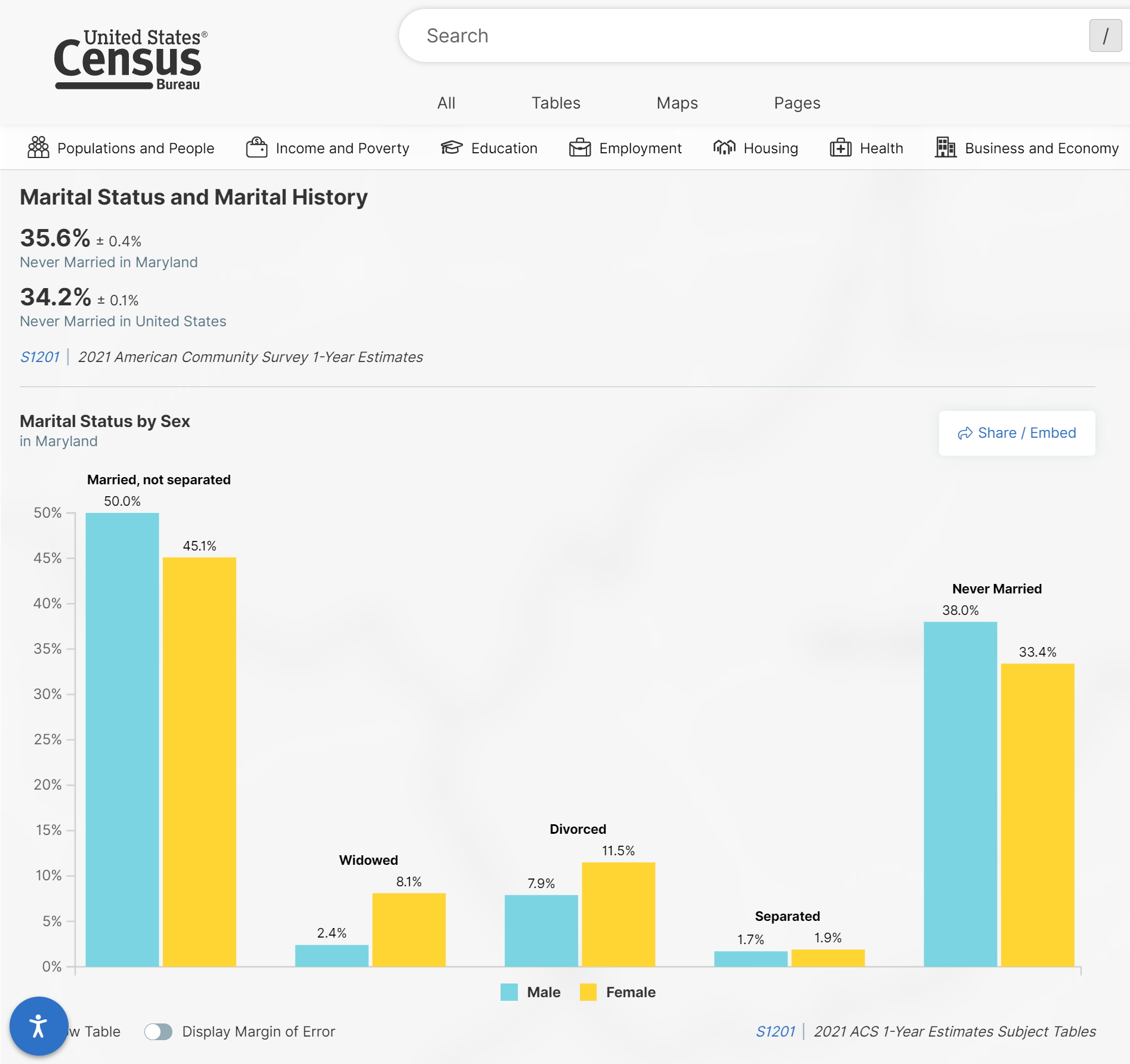
- New bar charts added to the Marital Status and Marital History section of the Geography Profiles. This update provides more meaningful information in the bar chart.
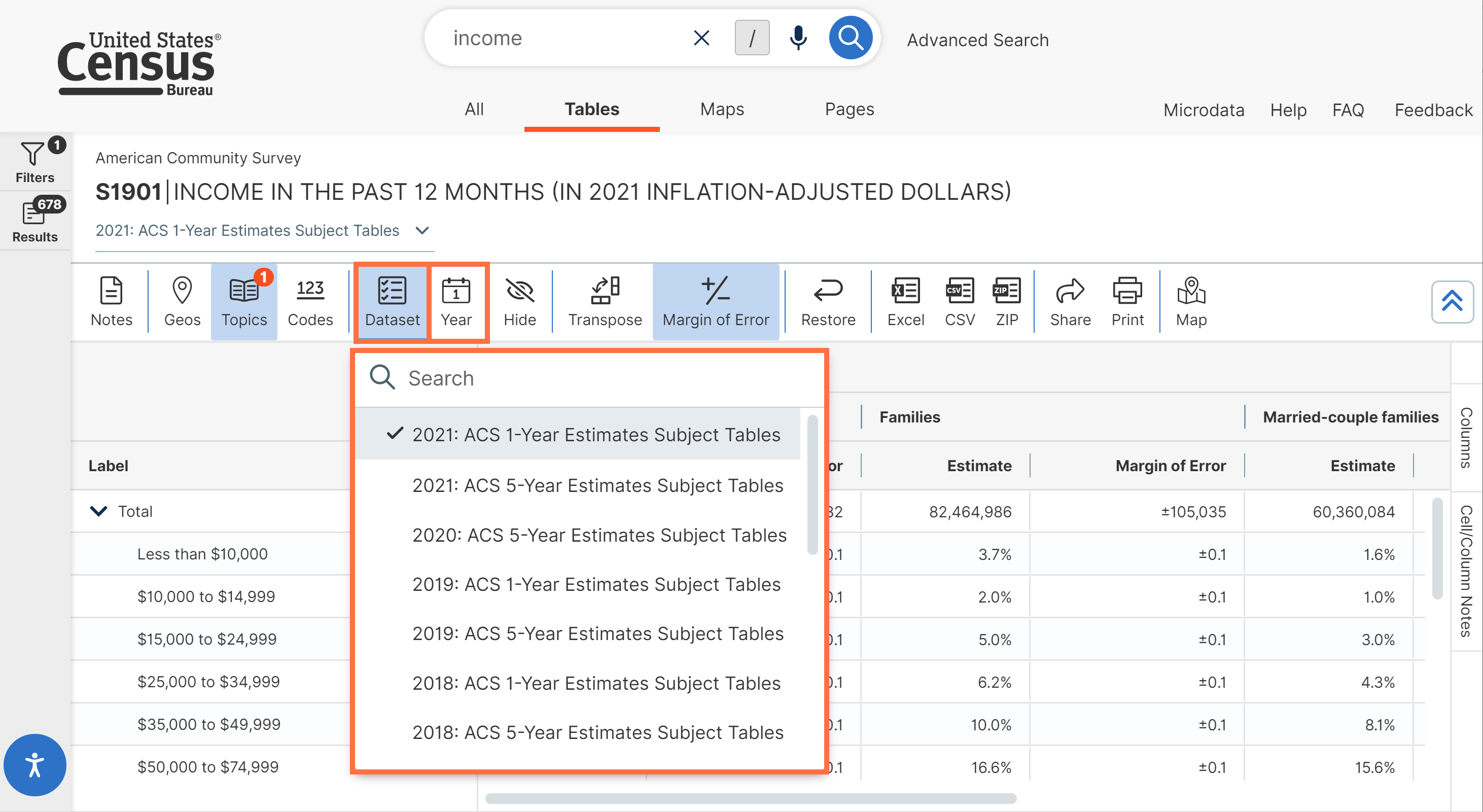
- New buttons for “Dataset” and “Year” added to the table toolbar. These buttons provide an intuitive option for you to switch between all available datasets and years applicable to the table you are currently viewing. They provide a helpful way for you to interact with the table and replace the previous “Survey” button.
- Simplified column controls. We removed the reset column buttons, because the “Restore” button at the top of the table already provides functionality to return to the default table view.
- Fixes to 16 defects, including fixes that allow you to:
- View maps in the Geography Profiles on mobile devices without having the controls cover up the map
- Automatically experience a readjusted zoom area on the map as you make updates to your selected geographies
On May 18, we released the following updates to the site:
- Improved application programming interface (API) functionality for time-series datasets that allow you to specify multiple time values in the same data request. This new feature allows you to add multiple &time= predicates to your API data requests, as shown in the example below: api.census.gov/data/timeseries/eits/qfr?get=data_type_code,time_slot_id,seasonally_adj,category_code,cell_value,error_data&for=us:*&time=2012-Q3&time=2012-Q1
- Technical work to add time-outs to unusually large API data requests. This update helps ensure overall system performance is not negatively impacted by these types of large data requests.
- Behind-the-scenes work to update suggested results in the typeahead search suggestions.
- Fixes to 20 defects, including fixes that allow you to:
- Use a keyboard to access the microphone button that enables speech-to-text functionality in the single search bar
- View relevant pop-up windows and warning messages prior to clearing filters
- Use the ampersand character ‘&’ in the single search bar
On May 4, we released the following updates to the site:
- New option that allows you to clear filters when running a new search in the single search bar. This toggle allows you to clear filter check boxes you previously selected when running a new search.
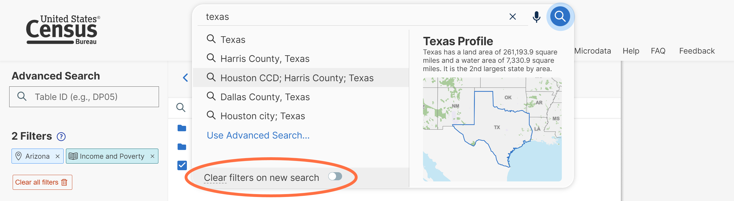
Please note that by default, the toggle is turned off. If you turn on the toggle it will persist across visits to the site unless you manually change it again.
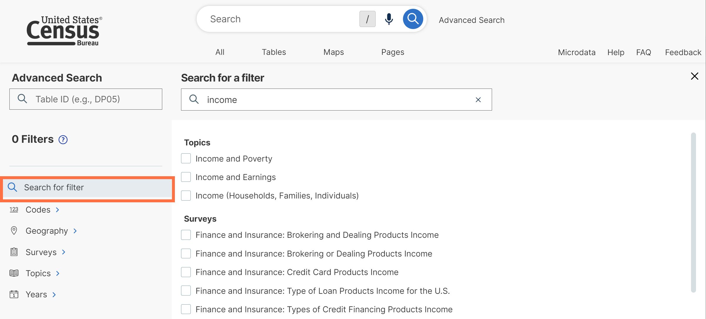
- Improved aesthetics of filter panel side panel and a new label for “Search for filter.” We made this wording improvement to clarify the purpose of the search option.
- Behind-the-scenes technical updates to suggested results for Profiles. This work supports efforts in future releases to provide more relevant Profile suggestions based on your search.
- Technical work to improve structured data for content on data.census.gov so that external search engines can find the content and display more information and context to users.
- Fixes to 19 defects, including fixes that allow you to:
- Get consistent search results in instances when a period is added to the search terms
- View special characters correctly in downloaded tables
- View NAICS codes in numeric order in the variables drop-down menu of maps
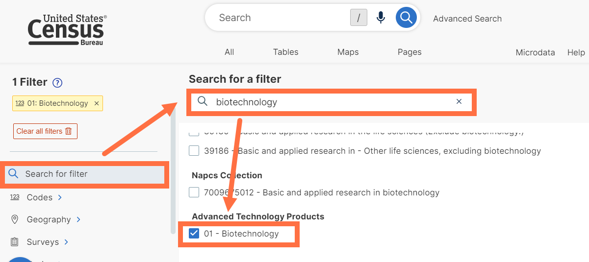
On July 6, we released the following updates to the site:
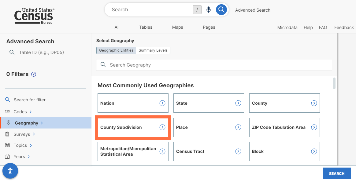
- New “County Subdivision” box added the “Most Commonly Used Geographies” section of the filter panel. This update makes it easier to select county subdivisions such as towns, townships, and boroughs.
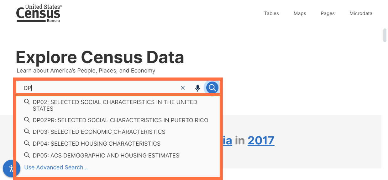
- Improved typeahead search. With this release, you will now get search suggestions after typing 2 characters in the single search bar instead of 3.
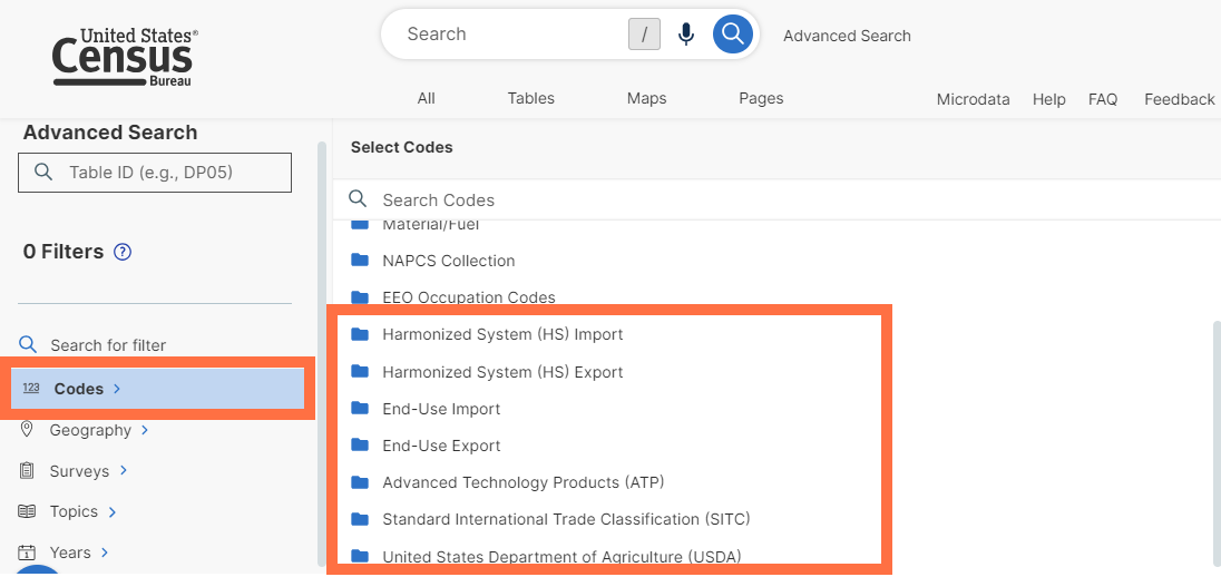
- New options in the filter panel to select the following sets of codes
- Harmonized System (HS) Export Codes
- End-Use Import Codes
- End-Use Export Codes
- Advanced Technology Products (ATP)
- Standard International Trade Classification (SITC) Codes
- United States Department of Agriculture (USDA) Codes
*These new filter panel categories will contain folders and check boxes when relevant datasets from the International Trade program are added to data.census.gov in the future.
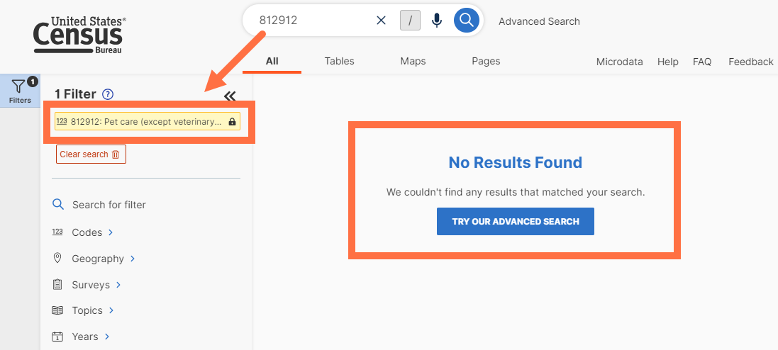
- Improved recognition of search terms and better messaging in instances when the search terms do not result in data tables. You will now see filter matches for your search terms even when the site does not have data tables to support the search criteria. These situations are indicated by “No results found” and similar messages.
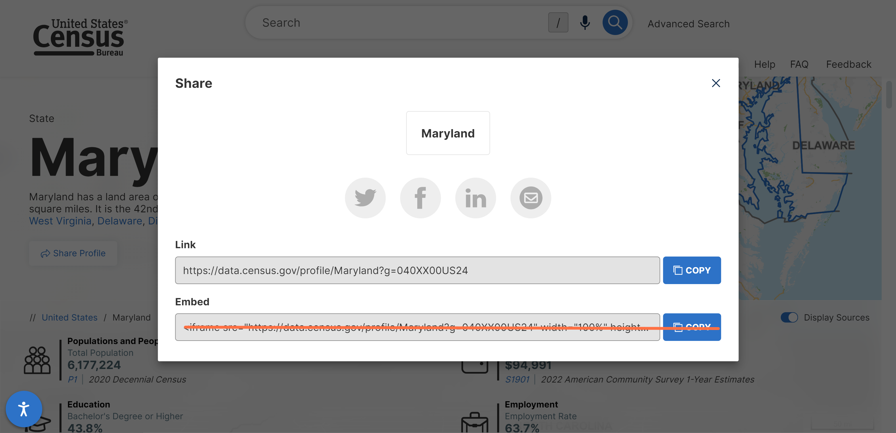
- New deep links that allow you to share a particular section of a Geography or Industry Profile. When you click one of tabs at the top of a profile, the section you navigated to will now be captured in the URL. For example, after clicking the “Education” tab, the URL will read data.census.gov/profile/Maryland?g=040XX00US24#education
When visiting the link, you will be taken to the education section of the profile automatically.
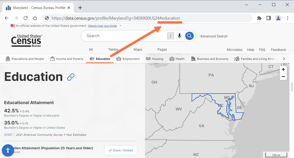
You can also right click the link icon to get the URL for that section of the profile.
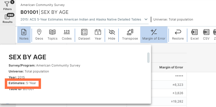
- Improved labeling in the “Notes” section of American Community Survey data tables. You will now see the “Estimates” section in the notes to indicate whether the table is from the ACS 5-year or ACS 1-year estimates.
- Technical work to make back-end data transfer processes run more smoothly.
- Fixes to 27 defects, including fixes that allow you to:
- View the “all census tracts in United States” geography selection on a map
- Maintain universe restrictions when switching between vintages in the Microdata Access Tool (MDAT)
- View correct topic tags when accessing tables that are provided for different population groups from the decennial census
- Access data for all voting districts in a state
On Aug 3, we released the following updates to the site (see Release Notes):
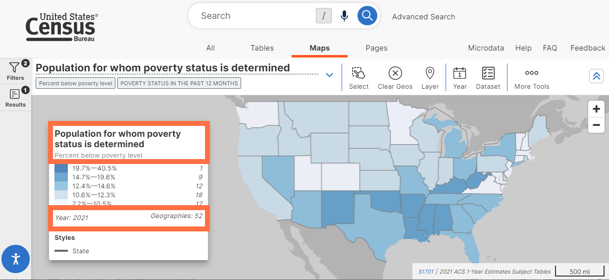
- Redesigned map variable selection process. With this update, we replaced the previous “Variables” button with a drop-down menu. This menu shows you map variables in a readable, hierarchical format that is similar to the table display. Drop-down menus in the “Dimensions” section allow you to switch between different categories available for the map that further contextualize your variable selection. The map also defaults to show percentages when available and the new “Units” section allows you to switch between percentages and numbers. Percentages must be provided in the corresponding table display to be available for the map.
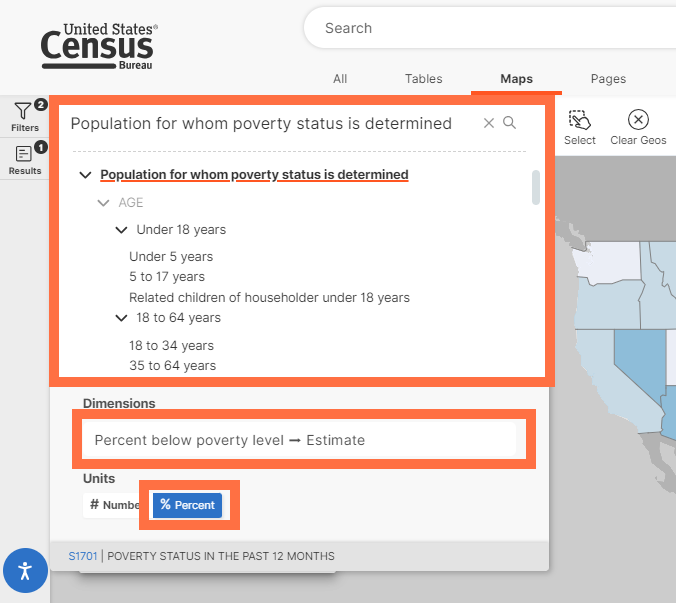
- Simplified labeling for the variable shown in the variable drop-down menu. Variable labels are now broken down into manageable parts. The primary selection is shown in large font for easy readability, with the full context included in the boxes below the variable.
- Improved readability of map legend. This new legend shows the primary variable in bold font, with the variable context included right below it. The legend now includes the year, as well as updated language for the number of geographies selected.
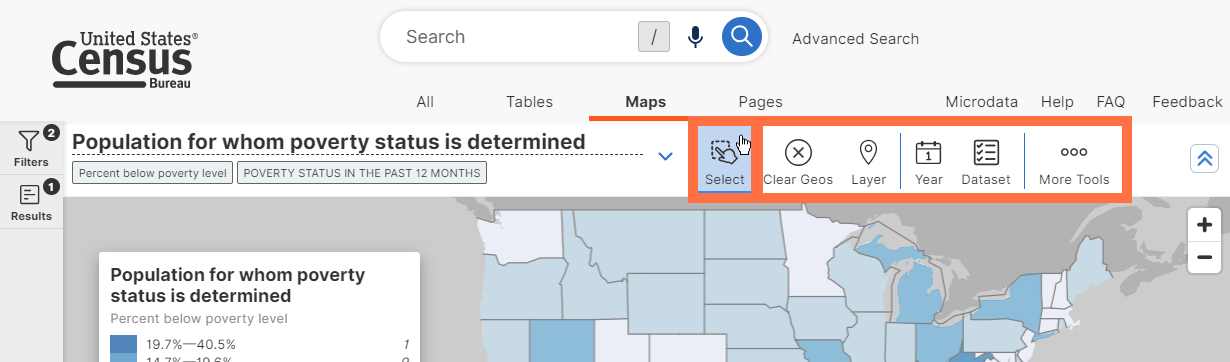
- Improved “Select” and “Identify” buttons on the map. When you use these features, the other buttons on the map will no longer disappear, providing a consistent experience for you to make use of all map features.
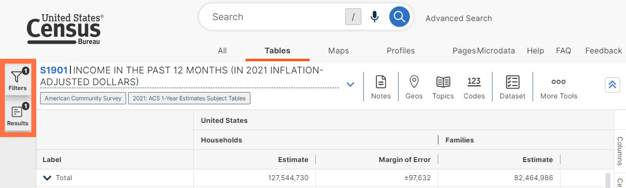
- Integration of table header details into the table toolbar. The table ID, table title, survey/program, universe statement, and product will be all be shown as part of the newly redesigned product drop-down menu. We placed these details alongside the other table controls for your convenience, and to allow more room on your screen for the table display.
- Ability to search for UTO Codesets (International Codesets) in the “search for filter” section of the advanced search. These codesets include results from the recently added Harmonized System (HS) Import, Harmonized System (HS) Export, End-Use Import, End-Use Export, Advanced Technology Products (ATP), Standard International Trade Classification (SITC) and United States Department of Agriculture (USDA). This feature will support future releases of international trade data tables and will not be visible until the corresponding data are release.
- Behind-the-scenes improvements to the API
- Technical updates to improve our internal data review
- Fixes to 9 defects, including fixes that allow you to:
- Download data tables with “all places in U.S.” geography selection
- Select public use microdata areas (PUMAs) in the Microdata Access Tool without slow response times
On Sept 28, we released the following updates to the site:
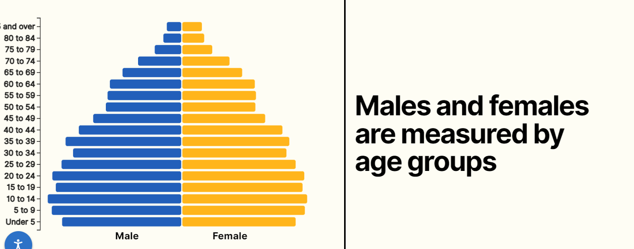
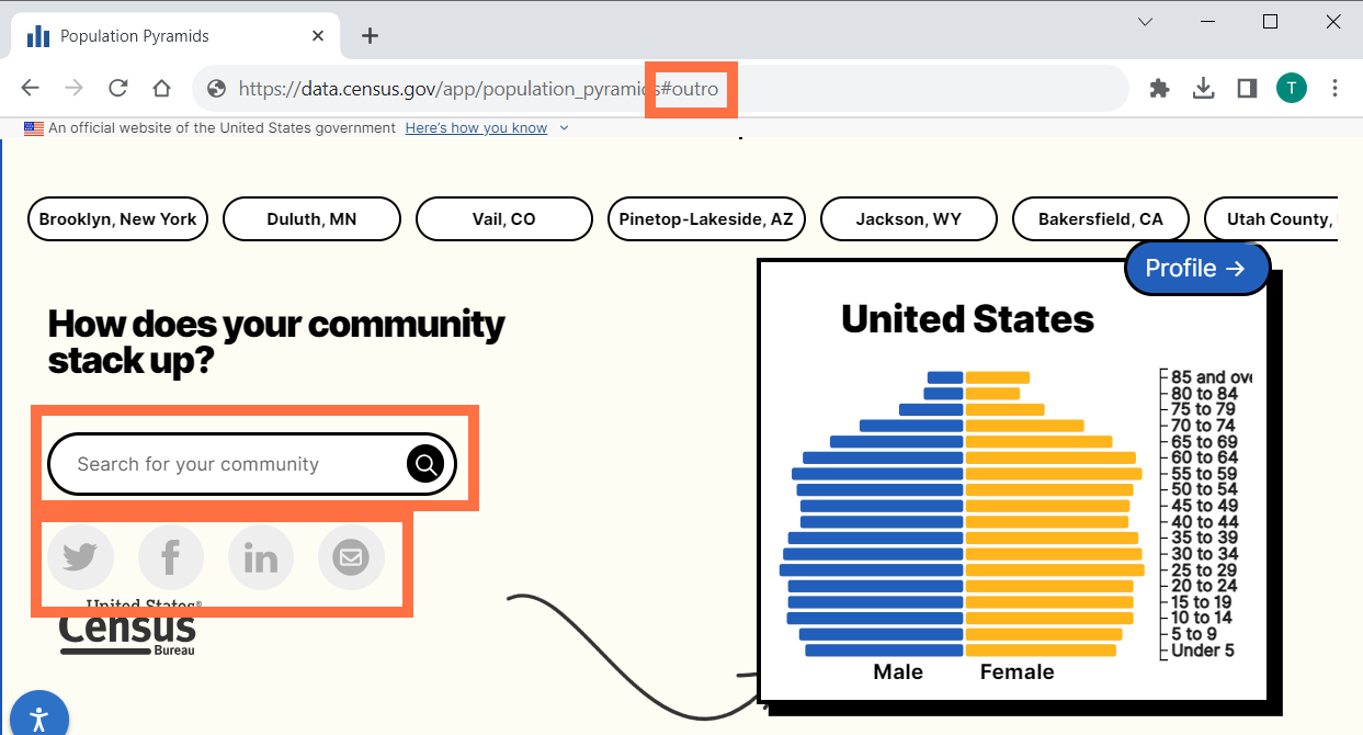
- New Pop Story App, accessible at data.census.gov/app/population_pyramids This app showcases the use of population pyramids to tell data stories and features a widget at the end which allows you to find the population pyramid for your community.
Pop Story App Features:
◦ Intuitive scrolling, keyboard controls, and scalable text to help you navigate through the application with ease.
◦ Widget allows you to find population pyramid for the following geographic areas: Nation, state, county, city/town, ZIP code tabulation area, congressional district, school district, American Indian area, Alaska Native area, and Hawaiian Homeland.
◦ Buttons to share the Pop Story widget on twitter, Facebook, LinkedIn, and email.
◦ URLs capture different sections of the Pop Story app.
- New Cite button. This automatically provides a citation for the table in common formats that can be copied: MLA, APA, Chicago, and Harvard. The button also contains options to export the citation for BibTeX and Reference Manager.
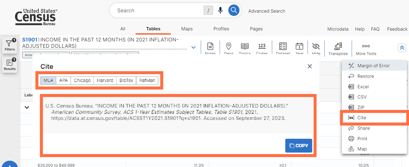
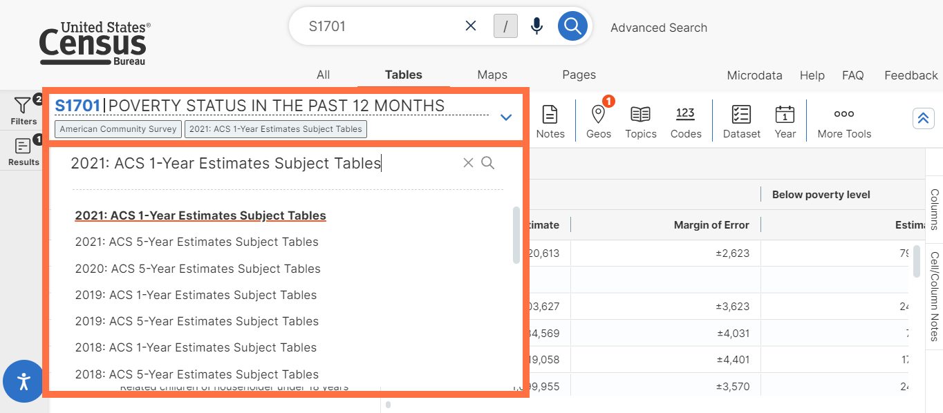
- Updated URL structure for capturing table IDs. This update allows for better connections between data.census.gov and Google Search. With this update, the dataset selection and table ID are shown as indicated in bold: https://data.census.gov/table/ACSST1Y2021.S1901?q=income
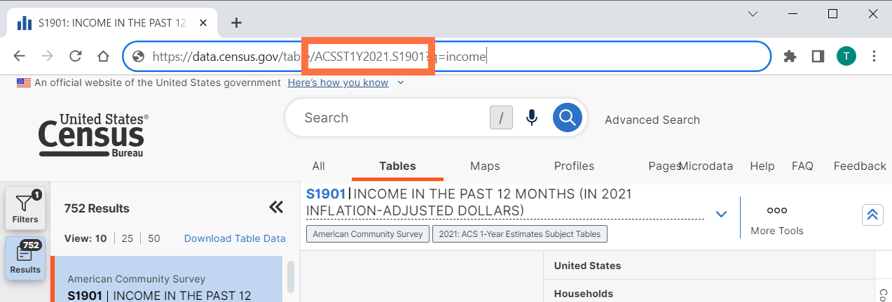
Previous links with the old URL convention will continue to function and redirect.
- Persistence when clicking the Filters and Results buttons. When clicking the Filters button, your selection will be maintained until you click it again. When clicking the Results button, your selection will be maintained unless you click the button again or run a new search.
- Updated Profile results that default to ACS 1-year estimates when available for the geography, providing a consistent experience throughout the Profile.
- Increased font size of text on data.census.gov to help you read the content more easily.
- Technical updates to help improve speed of future updates to data.census.gov.
- Fixes to 36 defects.
On Sept 7, we released the following updates to the site:
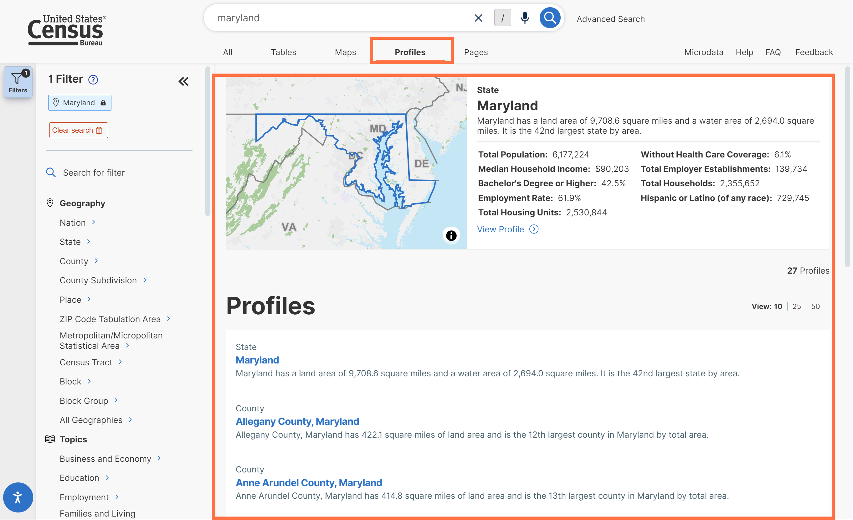
- New Profiles tab accessible throughout the site. This tab makes it easier to navigate to Geography and Industry Profiles. It also features a list of Profiles to choose from that are relevant to your search.
- Improved width, design, and hover effects for the filter and results button panel.
- Redesign of the filter side panel. With this update, you will now see the filter subcategories shown by default, making it easier to explore the available options.
As you click through the filter panel, clicking an item with a chevron will provide more detailed options to choose from and clicking a check box will add the filter as a final search selection.
- Update to ensure that you see all dimensions in the variable toolbar and map legend, including detailed population groups and Equal Employment Opportunity (EEO) codes. This makes sure you can always see the full context for the mapped variable.
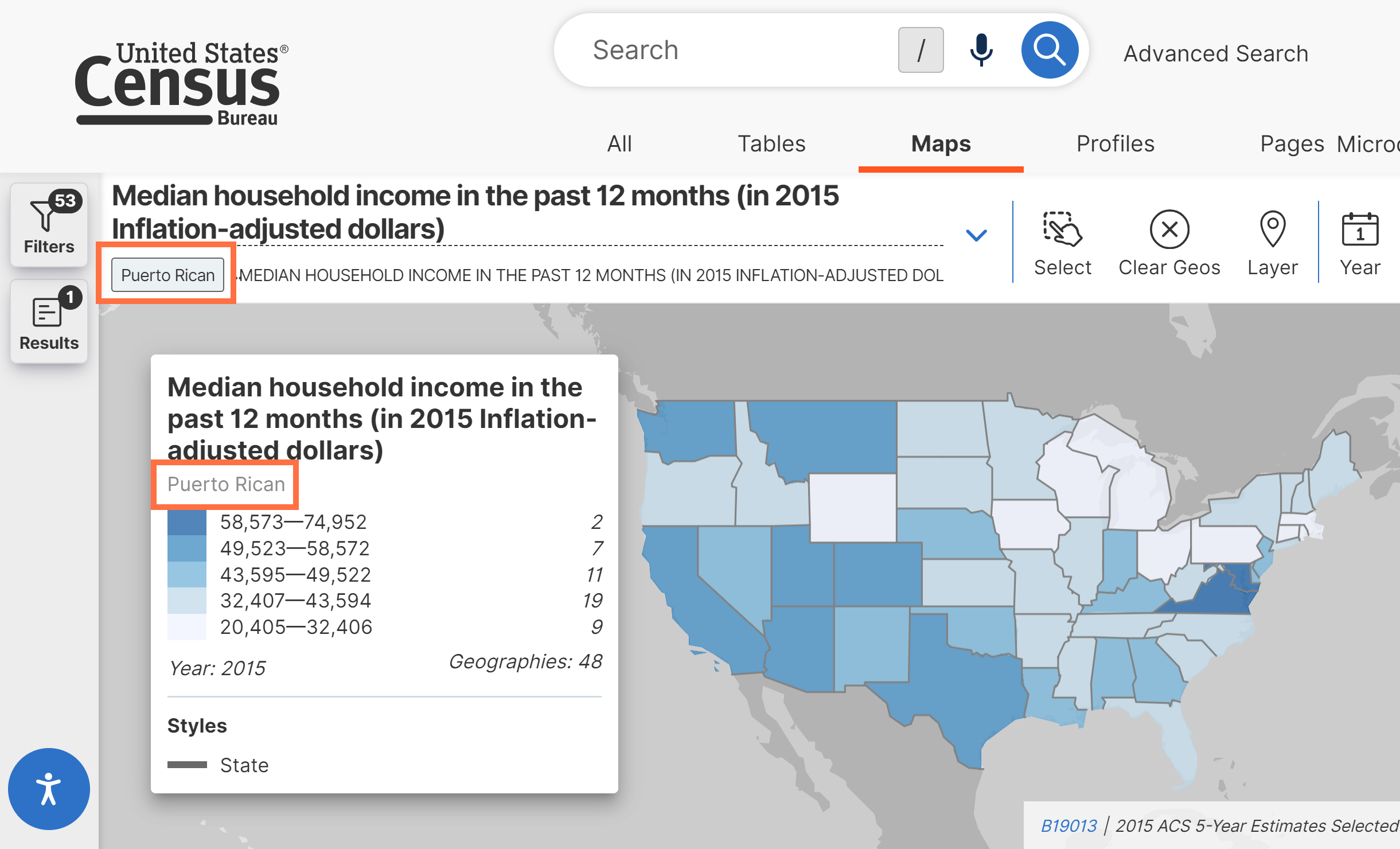
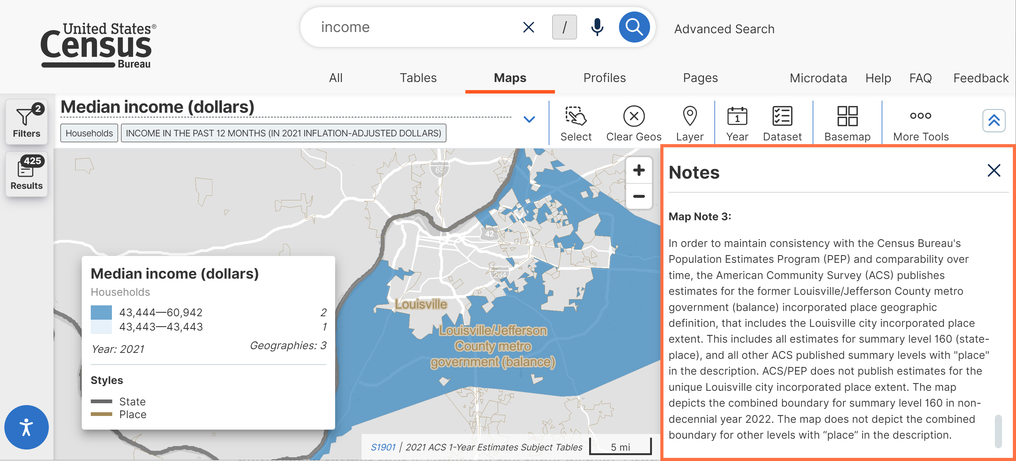
- New map note explaining how data is provided for Louisville, KY. This map note is displayed when making maps with American Community Survey (ACS) data.
- Behind-the-scenes updates to allow searches for world geographies. This work is being done to support international datasets on data.census.gov.
- Fixes for 19 defects, including fixes that allow you to:
- View correct table results when selecting filters for a topic and a detailed population group
- Select public use microdata areas (PUMAs) by state in the Microdata Access Tool
- Experience improved load times when using the single search bar
- View the correct number of result pages after editing the number of table results displayed at a time
On Oct 26, we released the following updates to the site:
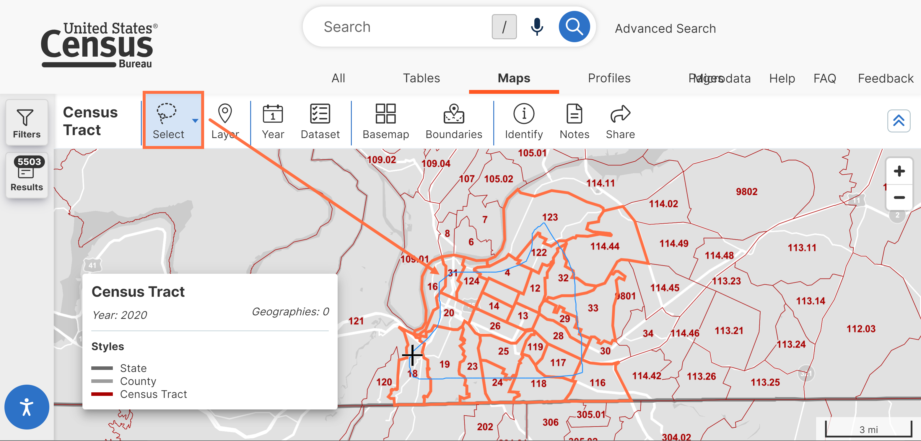
- New options to select geographies in bulk using a map, including:
◦ Circle Selection Tool: Draw a circle to select geographies
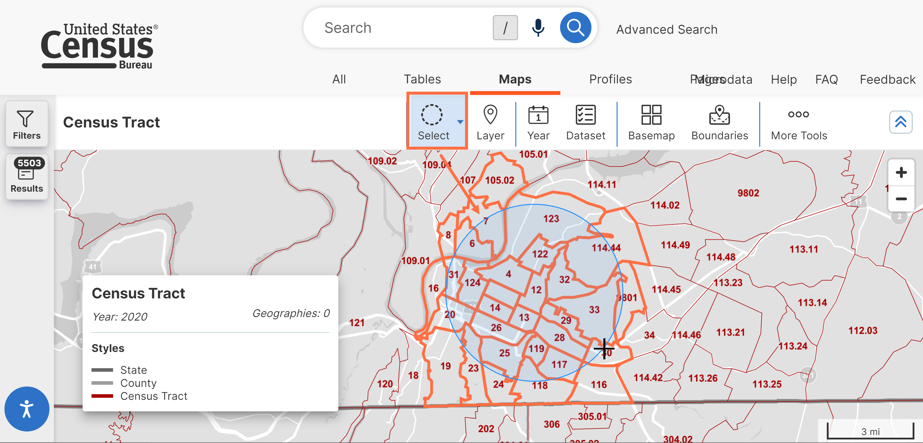
◦ Lasso Selection Tool: Draw a custom shape to select geographies
- Updated design of search bars throughout the filter panel. These appear consistent with the design of the main single search bar to provide a standard look for all search bars across the site.
- Removal of the ‘Embed’ option from the ‘Share Profile’ pop-up window, as this functionality was not supported. However, the functionality to embed individual visualizations within a Profile continue to be supported and remain accessible on data.census.gov.
- New sitemap that provides more details for external search engines to be able to link to data.census.gov content.
- Technical work to help improve internal review processes.
- Fixes to 6 defects, including fixes that allow you to:
- View population pyramids in the Pop Story App in one view that displays all labels.
- View chart text in the Pop Story App on mobile devices without overlapping text.
- See correct search results when using the phrases “town of” or “city of” in the single search bar.
On Nov 16, we released the following updates to the site:
- New filter hover effects. When hovering over a selected filter, you will now see a pop-up with the full label of the filter for easy readability.
- Improved ZIP download output. The previously included alternating annotation columns have been removed to simplify the output and make it easier to read. The information in these columns is already included as special characters the corresponding data columns
- Enhance the ability to recognize the search terms you type into the single search bar by implementing a neural network to recognize search criteria.
- Fixes to 9 defects, including fixes that allow you to:
- View featured statistics for key search terms at the top of the All Results page.
- Use map variable menu options that are responsive to your selections.
- Click between tables without arbitrarily keeping URL parameters from the last table.
- Get MLA citations in Excel downloads that contain the complete data.census.gov URL.
On Nov 7, we released the following updates to the site:
- A table notes toolbar, featuring new functionality that allows you to print and search the content of the table notes.
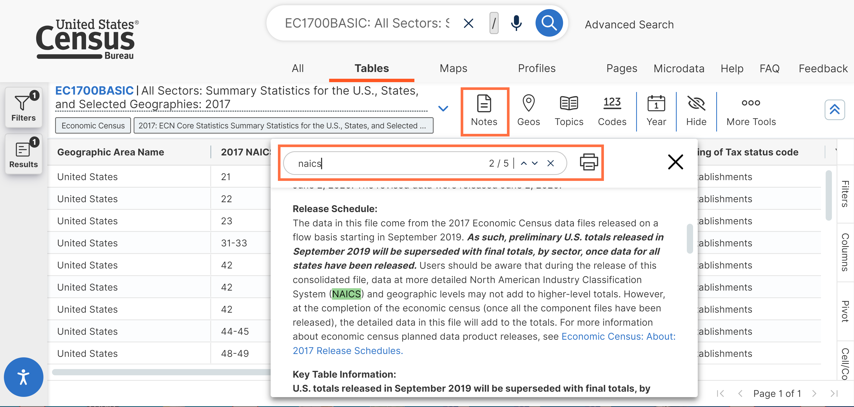
- Behind-the-scenes work to improve the future layout of table notes, which will allow you to navigate to different sections of the notes with a single click.
- Technical work to improve our ability to recognize the search criteria you enter in the single search bar. The benefits from this work will be added to the live site in future system releases.
- Fixes to 7 defects, including fixes that allow you to:
- Obtain complete citations for Annual Business Survey and Vehicle Inventory and Use Survey.
- View correct sections of population pyramids when scrolling through the Pop Story App.
- View data when navigating to new tables after having applied a custom filter.
Limitation |
Description |
Data |
This release does not include all Census Bureau datasets or data products. See our data table for a listing of data offered in data.census.gov. We will be providing support for additional data with future releases. Note: SF1 does not contain all previously released geographies. |
Browser |
Google Chrome is the recommended browser for the site. See the full list of supported browsers. |
Filters |
The topics and other options available within the filters continue to be updated during the releases. Users may notice some inconsistencies as we complete these updates. |
Order |
Geographies may not appear in alphabetical order, and estimates in the data downloads may not appear in the expected order. We are working to address this. |
Collections of Geographies |
1) We are continuing to add more options that allow you to select collections of geographies in a single click in the geography filters (Example: All census tracts in the United States). Please tell us what collections you would like us to add by emailing census.data@census.gov. 2) When the Summary Levels tab is turned on in the Geography filters, options to select collections of geographies in a single click may not appear at the top of the list. These options are sorted alphabetically and are intermingled with the individual selections. For example, the filter for “All Counties within the United States and Puerto Rico” is alphabetically sorted so that it appears between the words Alaska and American Samoa. |
Performance |
Some users are experiencing site freezing and inconsistent mapping results. Please copy the URL from the address bar and email census.data@census.gov so we can help troubleshoot if you run into any of these issues. |
The current print functionality works for small tables with a single geography. We are working to expand the print functionality in future releases so that it will print the entire table without cutting off the rows or columns. |
|
Navigation |
Users may experience inconsistencies when trying to use the back or forward buttons provided in the browser. Because of this, we recommend navigating between the different pages on data.census.gov using the tabs and clickable links we provide in the upper left (example: “All,” “Tables,” “Maps,” “Pages.”) For full navigation details and screenshots, please check out the FAQ: How do I navigate between the different pages? |
Geography Names |
Geography names may appear differently than in the previous releases because multiple deliveries of geography names were used in the past. We are working with our Geography Division to make sure geo names appear correctly on the site. |
Maps |
A current defect is causing intermittent issues where the map sometimes zooms to the middle of Kansas rather than your selected geography. As we work to resolve this issue, the workaround is to manually scroll and zoom to your selected geography. |
Download/ZIP in Firefox Browser |
You must allow pop-ups for data.census.gov in order to successfully see and open downloaded ZIP files when using Firefox. If you are having trouble completing the download (ZIP) process in Firefox: Please look for a message in your browser that says Firefox prevented a pop-up window from opening and click the “Options” button. Then allow pop-ups for data.census.gov. |
Unified Search: The single search bar allows you to type or speak phrases and supports searches by:
- Topic
- Geography (nation, state, county, place, county subdivision, congressional district, school district, ZIP Code, ZIP Code Tabulation Area, American Indian area, Alaska Native area, Hawaiian home land)
- Table name
- Table ID (single or multiple table IDs)
- North American Industry Classification System (NAICS) code
- Equal Employment Opportunity (EEO) occupation code
- Detailed population groups by race, ethnicity, ancestry, and county of birth
Other features of single search include:
- Entity extraction: Allows you to search multiple filters at once (example: a search for ‘poverty Maryland Virginia’ sets filters for ‘poverty,’ ‘Maryland,’ and ‘Virginia.’)
- Typeahead search suggestions: As you type into the single search bar, a box will appear with search suggestions that update in real time
- Spelling corrections, related search suggestions, and relevancy rules are applied to the free form text you enter in the search bar
- Search by Address: Allows you to type an address into a pop-up window to get a list of clickable geography filters the address falls within. This feature is accessible by clicking the geography pin icon in the single search bar on the landing page. The address search is powered by and limited to addresses recognized by the Census Geocoder. The search results provide a list of geography filters the address falls within, including the state, combined statistical area, county subdivision, urban area, place, county, state legislative district (upper and lower chambers), block, census tract, congressional district, and ZIP Code Tabulation Area (ZCTA).
Filters
Filters: Use filters as guided approach to browse all available options and precisely select them without having to come up with your own words for a search. Filters allow you to access all available search options, including more detailed options that are not supported through the single search bar.
Browse filters to find check boxes that allow you to select your desired:
- Code (industry, commodity, material/fuel, product and service, or occupation codes)
- Geography
- Survey
- Topic
- Year
North American Industry Classification System (NAICS), North American Product Classification System (NAPCS), and Equal Employment Opportunity (EEO) Occupation Codes are included in the code filters. The site supports options to select collections of codes in bulk.
The topics filters allow you to select detailed race, ethnicity, ancestry, and country of birth population groups. These filters include check boxes that allow you to select collections of population groups in a single click (example: “All available tribes” or “All available ancestries”).
“Search for a Filter” Search Box: The search box directly at the top of the filter panel allows you to select pre-defined search options to quickly choose your topic, geography, year, survey, or code without clicking through the filter panel. You must input an exact text match in order to find a filter and you must click the check box for the desired filter in order to select it.
Search within Filter Panels: Each filter panel has a search bar at the top of the panel that allows you to search the list of results for that single filter panel without having to scroll through the list. You must input an exact text match in order to find a result.
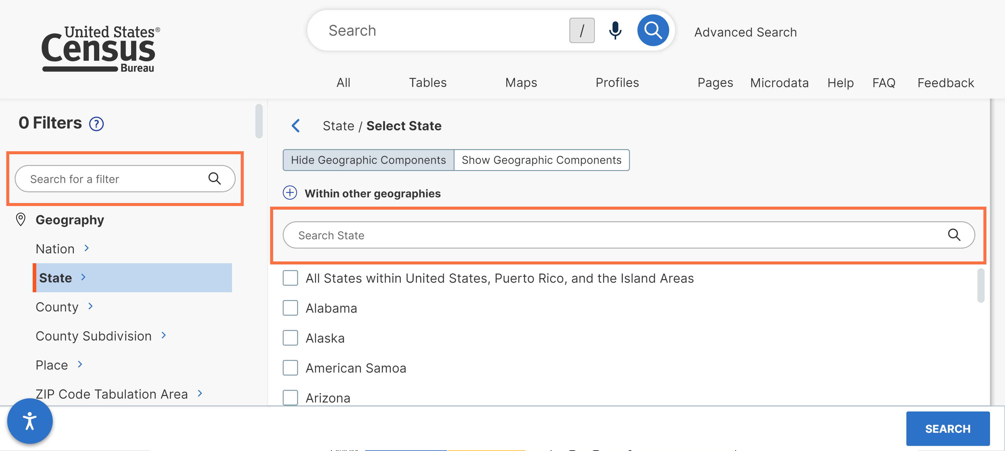
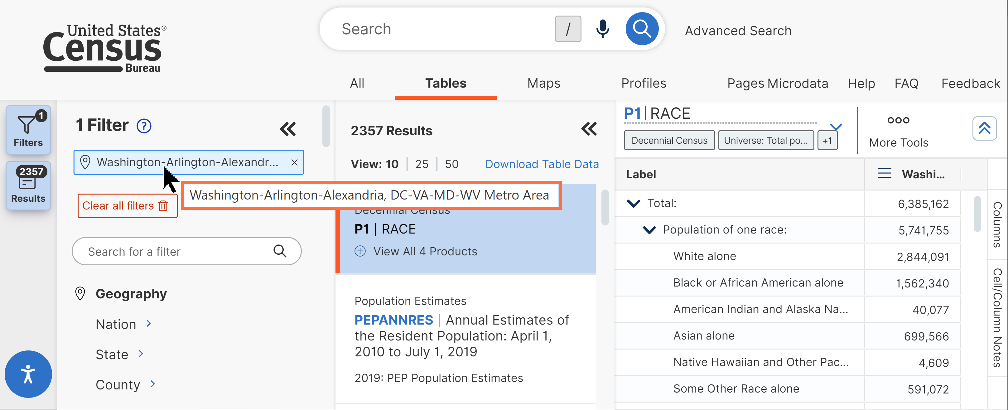
“Search Geography”: The search bar at the top of the main geography filter panel is a global geography filter search box. When you use this search, the site will provide a list of all types of geography filters that match your text.
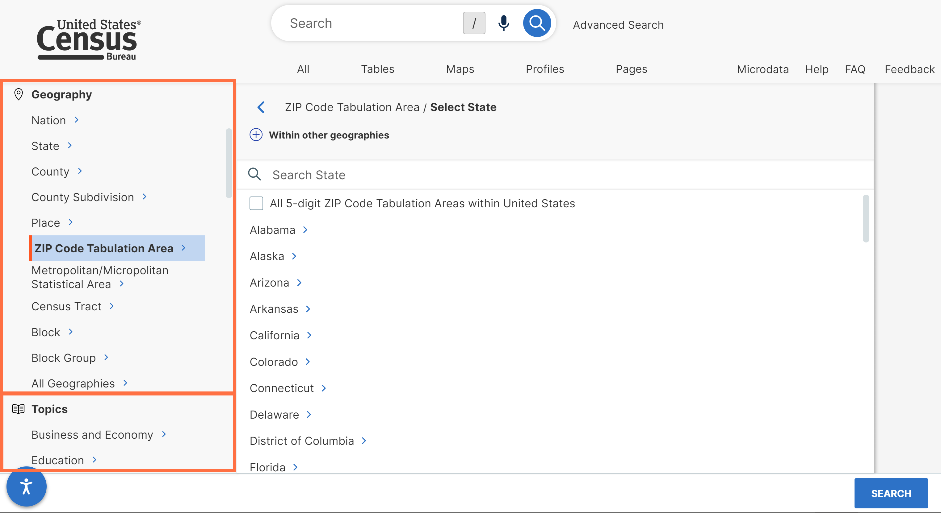
Summary Levels: The geography filters provide comprehensive access to nearly 250 geographic summary levels, listed in Appendix 1.
Dual Pathways to Select Your Geography: The filters offer two methods to select your geography
- Geographic Entities: By default, the site provides nine boxes with the most popular types of geographic areas, followed a collapsed list of all other geographic levels. This pathway helps you easily get to the most popular geographies by hiding some of the more complex geographies from the default views. You can still access these complex geographies if you need them by clicking the plus sign to expand “Within other geographies” or by clicking the “Show Geographic Components” tab.
- Summary Levels: The site allows you to click the “Show Summary Levels” tab to see a list of all geographic areas sorted by their 3-digit summary level codes.
Simplified Process to Select Geographies with Variants: Many geography lists are simplified to only show one label for each geography. When you select the label, it will provide data over time for all available vintages of that geography, even if the geography name has changed slightly over time. This provides shorter lists to scroll through and does not require you to know the history of label changes to get to the data you need.
These simplified lists are applied to all geographies with variants, including metropolitan/micropolitan statistical areas, congressional districts, state legislative districts, and urban areas.
Collections of Geographies: The site allows you to select collections of geographies in bulk by clicking a single check box. See Appendix 2 for a list of available collections.
Single Search Bar Displayed on All Pages: The single search bar appears at the top of all pages on data.census.gov, allowing you to refine your search without having to return to the landing page. When you edit the text in the single search bar, any filters you already selected by clicking a check box are automatically remembered so you won’t lose them in your search.
Filters Accessible on All Pages: The site provides a panel dedicated to selecting filters and viewing your selections. This panel is accessible across all pages on data.census.gov so you can review and refine your search criteria at any time without having to leave your current view or navigate between different parts of the site. The landing page also features a link to the “Advanced Search” that will take you directly to the filter options if you would like to begin your search by selecting filters.
Flexible Screen Layout: Most pages on data.census.gov provide flexibility to determine the layout through expandable and collapsible side panels:
- Expand the Filters panel when you want to view or edit your search criteria
- Expand the Results panel when you want to browse table results or select a new table
- Collapse the Filters/Results panels when you want to see more of the table or map across your screen
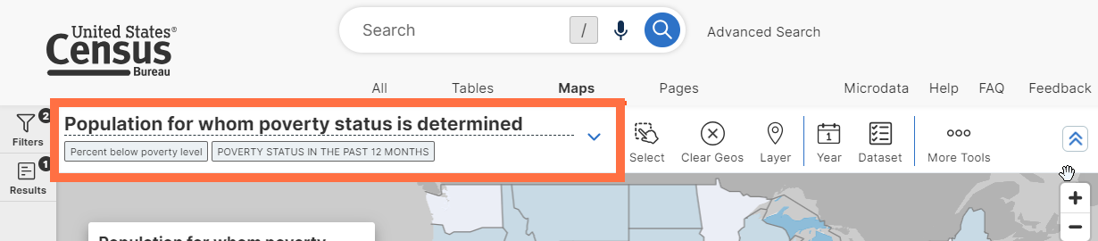
Navigation Options for “All,” “Tables,” “Maps” and “Pages”: The site features four tabs at the top that allow you to navigate between different types of search results: All, Tables, Maps, or Pages.
Clear a Search: Clicking the U.S. Census Bureau logo in the upper left allows you to clear all selections and navigates you back to the landing page so you can start a fresh search.
Edit a Search: The filter panel and single search bar show the search criteria that power your search.
- Filters with a lock icon tell you the search criteria is powered by the text you entered in the single search bar. You can remove these filters by editing the text in the single search bar.
- Filters with an “x” tell you the search criteria is based on a filter check box you selected. You can click the “x” to individually remove the filter.
All View of Search Results Content: After running a search, the All Results page will show you the top tables, maps, and web pages in one view. This is powered by consolidated curated results, meaning you may see prescribed search results and single estimates for selected topics based on geography and year.
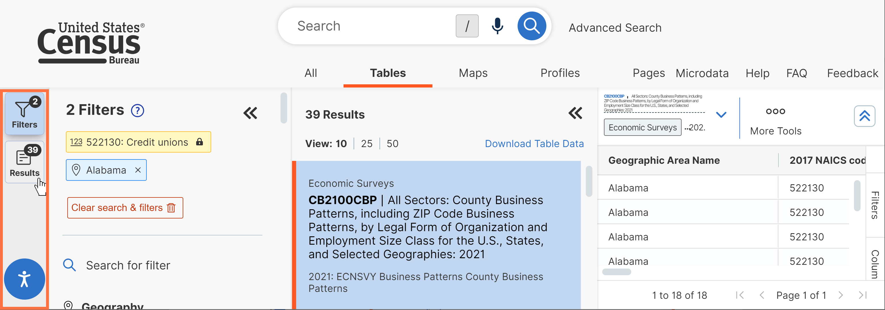
Browse Long Lists of Results: The site provides the first 10 results by default, and includes functionality to page through the remaining results from your search. You may increase the number of results provided on each page to 25 or 50, allowing you to browse a long list of results in fewer clicks.
Option to Browse List of Table Results Across Full Screen: The site often shows a table or map as you are browsing through the list of results. If you would prefer to browse a long list of table titles across your full screen before viewing a table, click the “View All Tables” button on the All Results page.
Table View: All table views have features that allow you to:
- Download and export the table in Excel, CSV, and ZIP file formats
- Print the table
- Share the table via social media, email, or by copying the link to your clipboard
- Cite the table using MLA, APA, Chicago, Harvard, BibTex, and RIS formats
- Add or remove geographies, years, codes, or population groups using filters
- Hide or show columns
- View API data and metadata queries for the table you are viewing
- Access, search, and print data notes and links to technical documentation
- Resize columns by moving the edge of the cell right/left in the column header
- Rearrange columns by dragging them
- Restore the table layout at the click of a button
Table Features Specific to Some Surveys/Programs: Some tables have more features that allow you to:
- Turn off the margin of error with a click of a button. By default, the margin of error will be displayed for relevant tables.
- Freeze columns in place so they remain in view as you scroll horizontally
- Sort a column in ascending or descending order by clicking the column header
- View definitions for column headers and data values in selected surveys by hovering over them
- Transpose the rows and columns in a table with the click of a button
- Pivot tables so you can customize the layout of flat data tables (available for tables from economic surveys/programs and the Population Estimates Program)
- Create a custom filter to keep only the data rows in the table that meet your specified criteria
- Access links to bulk data downloads (e.g. file transfer protocol sites)
- View pre-filtered versions of large tables (e.g. County Business Patterns) to more easily explore the most popular information the table provides
- View iterated tables by race, Hispanic origin, ancestry, and country of birth
The site offers the following ways to output the table:
Feature: |
Advantages: |
Limitations: |
Print: Click the Print button at the top of the table or use keyboard shortcuts: - Control + P (Windows) - Command + P (Mac) |
· Provides table and data notes with U.S. Census Bureau logo |
· Only small tables print successfully. We are working to expand this functionality. |
Copy/Paste: Select table cells, right click the table and choose “Copy” or “Copy with Headers” |
· Great to view the data · Your customizations to the table display carry over into the copied file |
· Maximum of 22,000 cells can be copied · Table notes and source information are not included |
Export: |
· Great to view the data · Provides the full table · Your customizations to the table display carry over into the copied file |
· Table must be visible on screen in order to export it |
Download (ZIP): Click the ZIP button at the top of the table and follow the prompts |
· Great option if you want to work with the data (e.g. sort, manipulate, or map) · You can download multiple tables at once |
· None of the customizations you made to the table display will be reflected in your downloaded file |
Large Table Download: Tables with more than 1,000 columns, 2.5 million cells, or tables that have an uncompressed download size of at least 4mb are considered large tables. These tables may be too large to display on screen. When you access a large table, the site will prompt you to download the table, which is the recommended action. It will also provide a link that gives you the option to try to load the large table on screen anyway, at the risk of experiencing long load times or browser instability.
Save Your Results: Copy the full URL from your address bar to save the table or map view. When you visit the URL later, it will take you back to the table view, as well as the list of other results based on your search criteria.
Save Your Search: Copy the URL from your address bar. Delete the parts of the URL related to your view. This will make sure the search runs fresh each time the URL loads and does not save any particular table or map view.
Learn about the different components of the URL and more functionality in the FAQ: How Do I Save My Results or Search.
Base Map: Choose from three settings for the primary base map that you see at all times as you use the selection and thematic maps:
- Basic: Provides streets, street names, and railroads based on your zoom level
- Detailed: Provides all the features of the basic map, as well as color-coded features for airports, hospitals, parks, and military installations
- None: View a map with none of the above features
Selection Map: In addition to the single search and geography filters, the map offers two additional ways to select your geographies:
- Click and select individual geographies
- Use rectangle, circle, and lasso selection tools to select a group of geographies in bulk
These selections carry over as you navigate between the maps and tables across the site. Over 100 geographic summary levels are supported. See the list of supported Map Layers for details on the available summary levels by year.
Thematic Map: Allows you to map an estimate from a data table across a single geographic layer. All thematic map views have features that allow you to:
- Choose the geographic layer, product type, data variable, and non-key dimensions
- Choose between numbers and percentages, when percentages are shown in the corresponding table display
- Search within the data variable drop down menu without having to scroll through the entire list
- Zoom in and out. Geography labels, boundaries, and other map features automatically populate based on the zoom level.
- Clear your selected geographies
- Adjust the color palette and transparency
- Increase or decrease the number of data classes in your legend
- Change the legend’s classification type (Natural Breaks, Quantile, Equal Interval, or Manual Breaks)
- Show boundaries and labels for multiple types of geographies at the same time
- Click on the map to identify the geographic areas a point falls within
- View a histogram that shows the range and frequency of data values on your map
- View the mean, standard deviation, skew, and kurtosis for the data values on your map
- Generate a table view of your selected variable and geography labels
- Download map boundaries in GeoJSON format
- Print the map from a PDF
- Share the map via social media, email, or by copying the link to your clipboard
- Move or collapse the map legend
You can access a profile that includes statistics and visualizations across topics, surveys, and programs for your geography in a single view. The profiles are fully accessible for these types of geographic areas: nation, states, counties, places, county subdivisions, congressional districts, school districts, ZIP codes/ZIP Code Tabulation Areas (ZCTAs), American Indian areas, Alaska Native areas, and Hawaiian home lands.
You may also manually edit the GEOID in the geography portion of the URL to navigate to a partial profile for any geographic type not specifically mentioned above. For these partial profiles, you will see featured statistics for the geography. Special bar charts and thematic maps are not currently available for these areas in the partial profile views.
Share/Embed Visualizations: The profiles feature enhanced options that allow you to access a link to share a visualization or embed it in your own html website. A variety of share buttons allow you to share the links via email, social media, or by copying the link to your clipboard.
Industry Profiles
Industry Profiles allow you to explore key data, visualizations, and maps for any 2–6-digit North American Industry Classification System (NAICS) code. These profiles are available at the state or national level.
To access and Industry Profile, simply run a search for a single NAICS code and up to one geography (nation or state), and then click the blue box on the All results page that says “Explore Data.”
Apps
Pop Story App: Accessible at data.census.gov/app/population_pyramids
The Pop Story App showcases the use of population pyramids to tell data stories and features an interactive widget at the end. This widget allows you to browse population pyramids for the nation, states, counties, cities/towns, ZIP code tabulation areas, congressional districts, school districts, American Indian areas, Alaska Native areas, and Hawaiian Homelands. You can also share population pyramids by email or social media.
Other Features
Modern Design Refresh: In Summer 2022, the site was updated to a new look and feel with modern design elements.
Navigation/Filtering Updates: In Winter 2021, significant improvements to navigation and filtering were applied to improve the user experience.
Refreshed Look and Feel: In Spring 2019, a major refresh was applied to the look and feel to improve the user experience and navigation throughout the site. Since then, we continue to make periodic tweaks based on user feedback, such as a refreshed landing page and better table display that requires less scrolling.
Use the Site on Mobile Devices: Responsive design allows you to experience the site in a way that has been optimized for your smartphone or tablet, in either portrait or landscape orientation
Architecture Enhancements: Includes ongoing research activities to identify mapping and table solutions to enable future features.
Accessibility Features: Accessibility control panel you can open by clicking the person icon in the lower left corner of the site. This panel allows you customize a variety of display settings including content scaling, dark mode, light contrast, dark contrast, low brightness, low saturation, high saturation, monochrome, hue shift, large cursor, and invert color. It also provides access to useful links and an option to reset back to the default settings.
The microdata access tool on data.census.gov/mdat allows you to create custom tables using public use microdata from the American Community Survey and Current Population Survey. The tool allows you to:
- Select variables and restrict the values you include in your analysis
- Recode variables to create custom groupings
- Select geographies from various summary levels depending on the survey (region, division, state, county, and public use microdata area)
- Format a custom table by dragging variables to the rows and columns
- Restrict your table universe
- Download or use API queries to output the table view or raw data
Limitations
Please be aware of the following limitations of Microdata Access:
- The site does not currently have the functionality to:
- Calculate medians, percentages, or margins of error
- Show data over time in a single table view
- Calculate an average over time for monthly CPS datasets
- Produce tables that are larger than 400 columns by 2000 rows
- Apply inflation-adjustment variables like ADJINC to dollar values in ACS datasets
- Place of work PUMAs (POWPUMAs), migration PUMAs (MIGPUMAs), and dual-vintage PUMAs are extremely difficult to use in Microdata Access because they are not available as selectable geographies. ACS datasets with dual-vintage PUMAs include the 2022, 2015, 2014, 2013, and 2012 ACS 5-Year PUMS.
- A current defect prevents you from downloading raw microdata when 5 or more geographies are selected in some datasets. As we work to resolve this issue, you can access these data using the API queries in the download screen.
Check out our Frequently Asked Questions to learn about using data.census.gov, the Census API, and the Microdata Access. Find out what data, features, and functionality is available.

Take Action
As we continue to develop new functionalities like search by address and advanced printing and download options, please let us know what features are important to you.
Please send your questions or comments on data.census.gov, Census API, or Microdata Access to census.data@census.gov
Page Last Revised - May 22, 2024
✕
Is this page helpful?
 Yes
Yes
 No
No
 Yes
Yes
 No
No✕
NO THANKS
255 characters maximum
 255 characters maximum reached
✕
Thank you for your feedback.
Comments or suggestions?

Comments or suggestions?